Sorry, you lost me here. This is what it looked like before I touched it:
I think this is actually the most serious error of all.
(What is it with this forum s/w that it often displays part of the URL instead of the picture?)
Sorry, you lost me here. This is what it looked like before I touched it:
I think this is actually the most serious error of all.
(What is it with this forum s/w that it often displays part of the URL instead of the picture?)
I think you refer to a problem with the way attached to node 5944737115 intersecting the highway 2006, also making two right-angle curves in way 2006. Are you? If this is what you actually describe as a problem, then it was your move of the node to create the problem. My screenshot above shows the geometry after I revert you node move. Probably you accidentally moved the node when trying to pan the map.
Here is the history with a visualization of you moving the node four meters:
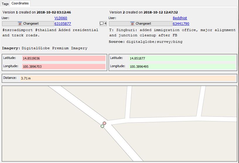
The current state of the map no longer shows this as I merged the road junction into the already existing node next to it.
I suspect that this node got moved with the whole area, when I adjusted the offset. I didn’t move the main road, as it was already correct and of course I have to click each node separately and if two are very close together then one of them will not get selected, as it’s not visible. I checked the history of both nodes and I was sure I my name didn’t feature in it, but who knows…
I’ll go and update my comment then.
Thanks for investigating.
Regards,
Peter.
Just a quick note to say thanks for the detail that people are adding in changeset discussion comments - that’s exactly what’s needed.
As promised on our meeting, here is a small map style for JSOM to highlight elements having “import=yes”, so in the majority of cases coming from Facebook.
The location is probably not forever, but I can leave the file there for the next few months, so you can directly add the following URL to JSOM as a map paint style.
https://downloads.osm-tools.org/FB_edits.mapcss
Thank you very much for the map paint style Stephan — it highlights the imports very well.
I visited a small town today, Ban Pin North, and didn’t really intend to do any major editing there but did want to add the name of the town to OSM. When I looked at the area in question using your paint style, the imports showed up very well. While there were no gross errors caused by the FB operator, my assessment is that many ways were carelessly drawn. The work, done about a year ago by RVR009, was generally not anything I would have wanted to have associated with my name.
I did not bother to write a changeset comment because my assessment was rather general and the work was done a year ago. Using GPS traces I adjusted the offset of the DigitalGlobe Standard imagery, and aligned ways (not all of which were created by RVR009), made a few obvious connections and removed the “import=yes” tag from the ways I checked.
I uploaded the imagery offset I used into the Imagery Offset Database as Ban Pin North.
Dave
I actually used to be indifferent to armchair mapping and imports, but recent encounters changed my mind.
Sigh
I really feel you now @Russ McD, @Tom Layo; one won’t see the reality in accuracy of these entered data unless one actually “live there”. Even the normal “imports” are usually based on data observed from on-the-ground. These corporate players seem to blatantly ignore the fact that fixing a map full of faulty data is much harder than adding correct data to a blank slate.
As a local resident in Bangkok, I had a recent run-in with corporate-based armchair mappers. In my case it’s Grab ridesharing company.
Their amount of changsets are much smaller than ones made by Facebook et al (around the magnitude of ~100 changesets); and as far as I know, they are 100% human-based team, not some nameless AI robots.
I began to notice the existence of their campaign, not because of their announcements, but due to the “obvious wrongs” that have been recently appearing in the area that I personally frequent to.
So I got curious, and began to do a proper on-the-ground verification of their edits: the result is not pretty.
With only just few samples, verified against ground observation, I found:
Overwrite of ground-surveyed data; broken local consistency.
Mis-upgrading of road levels (e.g. existing footway being upgraded to “service” despite the actual uses).
Mis-tagging of newly-added “roads” (e.g. new footway being tagged “service”); disastrous for routing.
Nonsensical objects tagging (e.g. a temple being re-tagged as road); ruined rendering.
Most of these “oops” are simply invisble from the satellite imagery, but glaringly obvious when you actually visit the place. Sifting through changsets and visiting places in their edits to fix them are like going down the rabbit hole, there’s no end of errors in sight.
And of course, I chided them directly in changset comments whenever I found these errors. But there are so many changesets that these will take several years to verify, in downtown Bangkok alone. Doing these erodes my sanity.
To date, I have verified just around < 0.5% of the edits done by their campaign. I estimate the count of errors in whole are to be many, many more. My current “verdict” is along the line of @Russ McD: the affected areas are now tainted; these can’t be trusted by satnav users anymore.
These are all I can say about corporate armchair mapping, from a very small subset that I actually went into the field to verify; now scale it to the entire rural Thailand.
Speaking of the scale of this “import” problem: don’t anyone realize that at the moment, amount of OSM edits from Facebook went through the roof and is now ranked as #1 in Thailand?
This is not a problem of AI; it is a problem of industrial-scale armchair mapping with zero ground-based verification. They are leaving their mess for us unpaid contributors to fix, case-by-case, for a several lifetime.
I condemn Facebook for this massive scale of data vandalism, and OSMF Data Working Group for their inaction.
With these, while I won’t quit contributing to my area in Bangkok, I don’t have the heart to recommend OSM for general uses in Thailand (and much less with satnav use) to anyone, anymore.
The damages are done. As a local user, my position on this is a firm: speedy deletion.
Erm - has anyone ever reported problems in Thailand with GRAB or Global Logic (their contractor) to the DWG ? I’m not seeing any tickets, but there may have been informal contact. I’m aware of reported problems in Indonesia (see e.g. https://www.openstreetmap.org/user_blocks/1882 and https://www.openstreetmap.org/user/harrymahar/diary/43671 from earlier this year), but nothing from Thailand.
For completeness - the list of GRAB contractors that I am aware of is at https://github.com/GRABOSM/Grab-Data/blob/master/Grab%20Data%20Team .
If there are current issues that need investigating with GRAB users please let us know. To be useful what we need are links to problem changesets and a description of what the problem is. Also if possible, with a changeset discussion history that shows that you reported the problem to them and they did nothing about it.
Please keep this thread strictly about Facebook edits. Please comment in detail at changesets what they did wrong. refer to the OSM id of the elements in question. Maybe even take a screenshot (snipping tool in windows). postimages.org allows hosting of them.
This is the task for Grab:
https://forum.openstreetmap.org/viewtopic.php?id=64075
Also comment here on changesets. As up to now we have very little to no complaints about them (they are not that active around Chiang Mai), please refer to commented changesets there as well.
I’ve just reviewed Yasothon province where I worked for 2 months. FB has changed many of my unclassified roads to tracks. Some are 8-9 meters wide, connect villages, nothing about them is agricultural. Then never contacted me before changing, something I would have done.
I wrote comments, and will change them back if FB doesn’t.
Hi Tom,
Changing community data like this was completely against our editing policies and the editor should not have done it. I believe I have reverted most of the tag changes and will continue to clean up anything else I find. Thank you for bringing this to my attention.
Thanks, Jeff
But I am wondering, do we have to point out every error? Because it’s usually easier to just fix them than to post a comment.
If we have to do this, I am in favor of a major revert.
Is FB willing to do a review of all their additions/changes? You have all the data, we have nothing but random checks.
I hope you can see the problem for us.
Regards, Tom
Hi all. I completed a small software to collect statistical data regarding FB edits quality by sampling random edits. As software would need a bit more work to be suitable for open public access, I just sent out the link to the participants of our meeting as we there also discussed about the specific problems. Directly contact me if you are also interested.
Hope we can come up in a week or two with some statistics about how frequently bad tagging is.
Side-note: we said to focus on ways created by Facebook. Falsely changing existing tags as outlined above by Tom would not be caught.
I am looking forward to Stephan’s software, thanks. But I do have to gripe about his unfair choice of words.
No where in my post do I advocate doing anything ‘falsely’. I have fixed lots of FB roads for as long as they have been around. Usually I remove the tag ‘import’, as Stephan said to do. This is called ‘editing’.
The point of my post seems clear to me. I ask FB if they will consider doing some QA by reviewing their imports (just like we are planning with Stephan’s software). And it in fact is easier to fix a problem than to write a comment.
Just to avoid expectations we can’t fulfill: we plan to create statistics about the rate of tagging problems severely harming routing.
I would say a rate of one or more per hundred ways is certainly too much. Maybe we have to be even stricter.
Initial feedback is coming in. Ways first added as unclassified and later deleted again by Facebook seem to cause confusion.
I have been fairly uninvolved with mapping in Thailand since the FB team began their work so I’ve tended to minimize the bad and accentuate the positive up to now. In checking out some of the areas Stephan had outlined for use with his FB-checking tool, I stumbled into a whole nest of awful mapping done by FB. I commented on three changesets and took screenshots to include with this post. The issue of road classification is separate from these observations. This is just about slipshod work, sloppy mapping.
I was appalled to see how many ways simply end and were left “dangling” even though it’s glaringly obvious that they continue and eventually intersect with another way. How a team whose implicit concern is to make routing easier, to make connections, as opposed to adding water features or landcover, could consider their work finished in this area is both puzzling and disturbing.
The screenshots use Stephan’s mappaint JOSM addon so the FB imports are clearly shown. I would be embarrassed to have mapped this area and left it in the condition you see in the screenshots. The approximate coordinates of the center of the photos are also given so you can navigate to the area yourself.
I left changeset comments asking about a few of the dangling ways in the screenshots. There were simply too many to enumerate and comment about individually.
Holy moly, what a mess! While I still don’t think reverting their work is the best way to resolve this problem, it’s going to take quite a while to fix all the loose ends they’ve left lying around.
[1] https://www.dropbox.com/s/um9hz50cscurmop/Dangling%20ends%20%2815.2929%2C%20104.8408%29.JPG?dl=0 (15.2895, 104.8728)
[2] https://www.dropbox.com/s/3q15xfyno6a3d7d/Dangling%20ends%20%2815.2929%2C%20104.8908%29.JPG?dl=0 (15.2929, 104.8908)
[3] https://www.dropbox.com/s/tzcrgi7d5ifwgop/Dangling%20ends%20%2815.2895%2C%20104.8728%29.JPG?dl=0
(15.2929, 104.8408)
Hi Dave,
I can give some context on what you are seeing here. We cut Thailand into squares for the import process so you will sometimes see hard edges like this. It can look ugly and incomplete but it is a temporary artifact of the process. We are two projects away from filling in this spot so you will see this resolved shortly.
-Jeff
Oh yes, Facebook is guilty as charged of sloppy, lazy, tardy mapping … as I said before, the old “bang it in, and move on” attitude, Its bad enough when see a simple “three sides of a square” driveway existing as 3 ways, because I guess the user gets to claim more “additions” that way, but what infuriates, is when they dont give a damn about making minor adjustments to improve the existing map.
Just happen to stumble across an an example in Phayao, where the existing tertiary พย.2015 was put in many years ago from a poor GPS trace. Yes the corners are rather squared off, and not many adjacent roads were added.
Then along comes Facebook…
Put in a residential road that connects on one these squared bends … bang it in … why bother to add a few nodes on the tertiary to smooth the corner out…
Connect a residential, don’t use the existing node, use the new one a few mts away that our AI suggests. Oh, then move the road (presumably for alignment). Wait, the tertiary now has a vicious Z-bend in it … shall I delete the existing node to make it correct … ah, bang it in, move on … gotta get my import quota up for the day …
All over the map, where Facebook has joined onto existing roads, a good mapper would connect to an existing node (if near), and move it for precision if necessary. Not Facebook, they seem to just miss the existing nodes by a couple of mts, which should not matter until one gets dragged.
And sat at my screen, its annoying … but when hurtling down a straight road on my motorbike … and my GPS suddenly screams “turn left, then immediate right”, then it really pisses me off … and Mr. Lazy VLD003, I’m talking to you.
The above, examples … both corrected now.
And while I’m in moaning mood … this changeset comment I made today, to a through road FB inputted as unclassified, with no unpaved tag, really applies to the whole of Thailand.
I have reproduced it here, in the hope it gets a wider audience:
This original import was over 12 months old … and since then we have been told FB has revised earlier data … so I’m guessing they have revised SOME earlier imports. Just how much was actually looked at ? 5% 10%, or less ?
And if you were heading from Hwy 1 to Dok Kham Tai, your GPS really would take you down this road if set to shortest distance, so I’m not just having a go at arbitrary roads. This is the real life cock-ups from FB I’m correcting on a daily basis, instead of using my time spent on OSM in a more productive manner.
… and read this and weep: https://www.openstreetmap.org/changeset/52049156
I have - literally - spent months mapping this area on motorbike and bicycle. There weren’t many paved roads left that I had not covered. I can now pick almost any FB road and say that it’s wrong. We are talking > 90%. Like Russ says, set your nav to shortest route and you are guaranteed to end up in the dirt. It’s especially fun in the rainy season, when some of these tracks turn to mud.
I repeat: it’s time for a mass-retag as tracks. It will be a hell of a lot less work to fix like that.
Having said all that, I have seen some really good work from FB lately and I have said so in a comment. Call a temporary halt to more data importing and get the mappers to go over all the work done so far.