Facebookstreetmap.com

Oh yes, Facebook is guilty as charged of sloppy, lazy, tardy mapping … as I said before, the old “bang it in, and move on” attitude, Its bad enough when see a simple “three sides of a square” driveway existing as 3 ways, because I guess the user gets to claim more “additions” that way, but what infuriates, is when they dont give a damn about making minor adjustments to improve the existing map.
Just happen to stumble across an an example in Phayao, where the existing tertiary พย.2015 was put in many years ago from a poor GPS trace. Yes the corners are rather squared off, and not many adjacent roads were added.
Then along comes Facebook…
Put in a residential road that connects on one these squared bends … bang it in … why bother to add a few nodes on the tertiary to smooth the corner out…

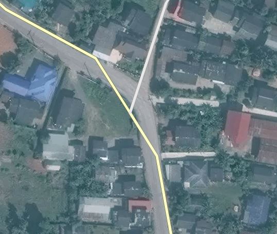
Connect a residential, don’t use the existing node, use the new one a few mts away that our AI suggests. Oh, then move the road (presumably for alignment). Wait, the tertiary now has a vicious Z-bend in it … shall I delete the existing node to make it correct … ah, bang it in, move on … gotta get my import quota up for the day …

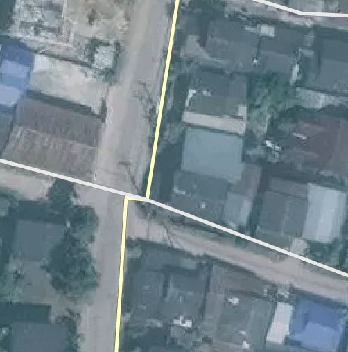
All over the map, where Facebook has joined onto existing roads, a good mapper would connect to an existing node (if near), and move it for precision if necessary. Not Facebook, they seem to just miss the existing nodes by a couple of mts, which should not matter until one gets dragged.

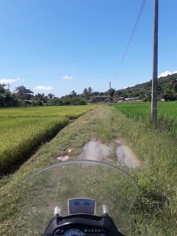
And sat at my screen, its annoying … but when hurtling down a straight road on my motorbike … and my GPS suddenly screams “turn left, then immediate right”, then it really pisses me off … and Mr. Lazy VLD003, I’m talking to you.

The above, examples … both corrected now.

And while I’m in moaning mood … this changeset comment I made today, to a through road FB inputted as unclassified, with no unpaved tag, really applies to the whole of Thailand.
I have reproduced it here, in the hope it gets a wider audience:

This original import was over 12 months old … and since then we have been told FB has revised earlier data … so I’m guessing they have revised SOME earlier imports. Just how much was actually looked at ? 5% 10%, or less ?

And if you were heading from Hwy 1 to Dok Kham Tai, your GPS really would take you down this road if set to shortest distance, so I’m not just having a go at arbitrary roads. This is the real life cock-ups from FB I’m correcting on a daily basis, instead of using my time spent on OSM in a more productive manner.

… and read this and weep: https://www.openstreetmap.org/changeset/52049156

I have - literally - spent months mapping this area on motorbike and bicycle. There weren’t many paved roads left that I had not covered. I can now pick almost any FB road and say that it’s wrong. We are talking > 90%. Like Russ says, set your nav to shortest route and you are guaranteed to end up in the dirt. It’s especially fun in the rainy season, when some of these tracks turn to mud.

I repeat: it’s time for a mass-retag as tracks. It will be a hell of a lot less work to fix like that.

Having said all that, I have seen some really good work from FB lately and I have said so in a comment. Call a temporary halt to more data importing and get the mappers to go over all the work done so far.

I strongly oppose mass re-tagging everything as a track. Changing something wrong into something wrong makes no sense.

How about mass-reverting everything into highway=road? Those ones will not be available for routing any more, but geometry will still be around waiting for proper tagging.

But: How will that be done? Another team of aerial mappers?

@Facebook: Please understand, that by trying to add everything you are adding a lot of corner-cases which should not be added without ground truth. Before we had a data-set which might have had a lot of gaps, but allowed you to do routing from village to village (not door to door), but you arrived. Now even the slightest mistake of either the driver or the data will lead to likely route you on a way better not be chosen, especially when driving a car. This extremely harms the reputation of OSM here and is shortly going to kill the project as we get the reputation of being dangerous.

Stephan,

I agree with all you said there. Tagging as ‘road’ is an option, but then these will not appear at all in most maps (Lambertus’ Garmin maps come to mind, I don’t know what Osmand does) and so they will be difficult to verify.

I propose instead to mass-tag at least the older FB contributions as unpaved. We can then see them on our devices as we travel and it will be relatively easy to fix up the few that are paved or a higher classification.

I want to end this on a positive note: I have seen some excellent mapping done recently. Perhaps the more experienced FB mappers could coach the junior ones and then go over all the old data, minus what had the import tag removed. I can see this as a win for everybody. But it will be a lot of work = $$$$$.

Another one, with pics :

And reading about the possibility of a mass revert to highway=road, well if those are not seen as routable by the engines, then at least we may have found a way to reach a partial solution, and one I would support. :confused:

In my opinion, simple retagging to road or track is a wrong solution. Though that might look better for users of “standard” maps.
The correct way to handle this is the creation of a custom map showing the FB imports in a different style, and treating them differently.
I just created a new bicycle map of Thailand for my Oregon. Below is a screenshot taken for some where in the South between Chumphon and Surat:

As you can see, the FB roads (regardless of their highway tag) are shown as small brown lines different from “normal” roads. They are treated as routable unpaved toll roads. This means that I’ll avoid them by default, and could use them with low prioirity when I switch routing on toll roads on.

I prefer this situation over the previous situation, where I often ran into “white maps”:

I see what you mean. But in doing so you are moving the problem from the source (data) to the renderer, i.e. all the good folks who provide the community with usable things, like Garmin maps or Osmand, to name just two that I use. A lot of these projects cover the whole world and we would have to ask every one of them to temporarily modify their systems to account for a problem we are having with one or two countries. I think this is just not going to happen.

If we don’t want to make them all unpaved by itself then adding the toll road tag as well seems a brilliant idea. That way you can make your own maps and show them as small brown lines. Everybody else will not normally ever get routed thru them and adventurous types can set their routing to directest, unpaved and toll and they will get to see any problems and can report or correct them.

I remember the good old days when riding into white space was the default almost anywhere in Thailand. Mapping was a real adventure then!

Hi All,

I sure don’t want to see any mass revert to tracks (FB or others), there are way too many now.

Many people here just don’t accept what a track is, and what an unclassified road is. If some roads are bad, I think we have to also accept that there is no tag for ‘bad road’. If we find a trail that ends in the weeds, it just shouldn’t be mapped. Or marked with an end. Trails-to-weeds should be visible on the imagery. My bicycling experience in Thailand is that many roads tagged as tracks are huge and well used 8 meter wide roads. Unpaved does not equal track. Maybe the definitions should be changed in the Wiki (I don’t want this either).

I’ve reviewed about 100 ways on Stephan’s software. Most of them are reasonably good, and it would be a shame to waste them for the maybe 20% that are bad. Just to be honest here, imagine if Stephan had included user ways. What percentage would pass? I’m guessing about the same as FB. My complaint with them is that they claim to be professional mappers and have every mapping aid, and should be held to a high standard. That they haven’t met. And their haste to import so many roads so quickly without oversight. But they seem to have deleted a bunch of ways, maybe they are making some effort. Some feed back from their QA (Jeff? DrishT?) would be nice now. FB potentially faces the loss of a year or so of investment, they should pay attention. What is the experience in other countries FB is mapping in?

With apologies to Russ and Bernard, a few bad road you encountered are anecdotes, not data. I once got stuck in the mud in a 4WD truck on a road marked ‘rural road’ on the official Iowa State road map. Some roads everywhere are seasonal.

What about expanding Stephan’s program to something like Mapdust? You get 10 random ways to evaluate and correct. Participation by FB mappers is mandatory, or prohibited, not sure. :-). 5 years should do it. Maybe we should try to recruit new mappers from prisons where the 5 years is already figured in (another smiley face).

I fix a few areas most every day and consider it progress. All I can do.

Yesterday I spent an hour or so looking at and removing the import=yes tag in an area that had been mapped by the FB team. Most of the residential roads were correctly tagged. There were a few that were done too quickly, that is, ways that extended through 90-degree turns with no break. Some unclassified ways were not broken into residential where they passed through towns. I did that and broke the long residentials into separate ways.

Overall, the work was acceptable and accomplished something that would have taken us a long time to do without their help. Reverting the ways I checked yesterday, admittedly only a small fraction of the FB ways added over the past year, would have been a huge mistake.

There were a lot of tracks in the area that I might have tagged unclassified and perhaps unpaved, so their interpretation of track was slightly different from mine but the error was on the side of being conservative. No harm in that, IMO.

So, I’m not sure what else to say. We Thailand mappers have discussions and even disagreements about exactly what is and what is not a track so I have trouble pointing my finger at the FB additions as being horrible or haphazard, In some cases, the work appears sloppy as I’ve mentioned before. In others, it’s fairly good.

A mixed bag but overall worth keeping. I’m definitely against reverting their additions. We’ll just have to live with them as we do other mappers who aren’t quite as committed as some of us are. Hell, look at the awful additions done by Maps.me users. Pitiful.

Dave

Say what? I was not aware that we are supposed to do either of those. I thought an unclassified is a feeder road for residentials?

I realise that this is heading off-topic, but I feel that I may have mapped it all wrong for all these years.

Firstly, I’ll quickly mention I’m totally against treating the problem like Bernhard suggests … not all of us have the ability to play with the style & type files to create these custom workaround maps. And as Beddhist states, we should be fixing this issue for all who use OSM, not just the computer savvy amongst us.

And Tom, you may feel this is anecdotal complaining … I assure you when you look at the FB stuff in the field, the errors are everywhere. I honestly feel we are just beginning to realise how much bad data exists out there. In the early days, we were spotting bad inputs, complaining, and supposedly the FB team were going to fix. I think the reality was they did improve, eventually, but never got to grips with fixing the older bad edits.

Yes, I accept the line between track and road may be blurred to some, but one thing should be clear, and its the focus of my complaining …** is it Paved or Unpaved** ? I could live with these 10-15 km “residential roads” that wind their way through fields and woods BUT ONLY IF THEY HAD TAGGED THE RELEVANT SECTIONS AS UNPAVED. At least that way, most routing engines would avoid them.

Facebook have offered to review, but its not being done quickly, or thoroughly enough … I see some roads being changed to tracks (or having the unpaved tag added) but then adjacent roads are left unchanged. Its a sort of dirt-dobber dance approach, in old USA parlance.

You will have seen my earlier post on the overgrown lane … well as I was riding in Lampang province with some time on my hands, I thought I would stop at a few more… and believe me, it doesn’t take long…

Way 538858336 : Marked as residential by Zvone, with no unpaved tag. Just look at it !

So then moving down to Lampang, in faceless Michael’s hurry to bang in a residential road (Way 537269623), he doesn’t bother to look at the road close enough to realise its actually a path way, with a locked gate between two walls. And to add insult, the changeset tag reads “Modified existing ways for better connectivity”. Are you telling me Micheal, that you just started joining up roads that look they just might connect ?

And almost everywhere, you will find find examples of driveways to private houses being added to the map, often behind locked gates too. Just one example amongst many, Way: 537465133, tagged as residential, with no access restrictions…

OK, while the latter may not be a big issue, the first two are. Need I go on ?
Beddhist is right - change every imported road to highway=road while we sort this bloody mess out !


And off-topic … Beddist, I have been doing the same as you … the main road through a village stays as unclassified, which if nothing else, should make the routing better.

I’m just discovering Mapillary. You can add these pictures to it and people editing in josm can load them as an imagery layer. I’ve also started to add mapillary tags to ways or nodes, so people stumbling across these will have a hint on where to look for images.

I almost always do that when the unclassified way connects with an obviously, small soi lined with houses. I mean, the character of the road changes from open country (usually) to a narrow, often one-lane street with houses. An unclassified way is just that, not important enough to be a numbered (“classified”) route but not residential either. They are significant because they connect towns or population centers and as such I wish there were some other way to tag them but that’s another story.

I edited this to say " I almost always" do that. It depends on whether the small soi is really small and residential.

Russ said he thinks routing tools distinguish between unclassified and residential but I’m not sure that’s the case. I use maps I compile with mkgmap and I do not think the internals of Garmin’s routing algorithms are well enough understood to make a case either for or against Russ’s contention. Be that as it may, what are your opinions about such preferences in other software, e.g., OSMAnd? So, how do others map an unclassified way when it enters a small village?

Russ,

You posted pictures of roads that ended in weeds or a barrier. If you can find these places again, could you post pictures of the imagery? It would be instructive to know if this was bad tagging or bad imagery that just could not show the difference.

Tom

Hi Tom,
I think in all cases, I mentioned the Way Number. it would be better if you viewed that in Potlatch, and took a look at the 3-4 aerials they presumably had to choose from, so as you can make a better opinion (and easier for me too :slight_smile: )
The vegetation may have grown a little being the end of rainy season, but the gist of the type of way should come from using the mappers initiative as to the surroundings as well as just the road surface.
The aerials would intimate dirt, whereas now, its more like grass … I don’t care, just make it unpaved if in doubt.
In the overgrown ways, the aerials do show more of a dirt road than would appear now, and with the locked gates, well as you know they are not easy to spot, but we are taught not to connect ways unless we are SURE they connect. If in doubt, leave it unconnected with a Fixme… which of course , takes too much time for the “bang it in team” to do.
Best, Russ.

Want a quick laugh before bedtime - guess who drew half of the Chiang Rai old airport runway as a residential road ?
Good old Zvone at FB. :laughing:
Changeset comment left to be ignored.
Road deleted.
zzzzzzzzz

While I want to acknowledge that FB mappers have come a long way, in ‘my area’ this picture of residential street 525947499 sums up their contributions nicely:

Don’t know about you all, but in line with the DWG advice, I have been relentlessly adding comments on FB changesets.
Guess how many replies ?
One!
Yes, a sweet little note from California saying sorry, they are improving, mapper no longer with us, learned from their lessons, blah, blah, blah.
Now the rest of my comments to the FB mappers must seem to have been a waste of typing… I guess they getting fed up of us now, given their wonderful project is coming to and end. I suppose my question today as to why dear Zvone has removed the unpaved tag from a canal service road, when its clear the way is still unpaved, will go unanswered.
I’m guessing Zvone has probably left them now, given her last edit was 2 months ago ? Her wonderful Avatar of the Owl sums it up - she dont give a hoot any more.
OK chaps, we are on our own again … lets automatically retag EVERY road marked as a FB import as highway=road, and slowly edit every one to its correct tag.
:rage:

+1 !

I’ve had a little more feedback, but it looks like they are just reacting to the comments, fixing one item. I agree, this needs to be tackled at scale: either they go through all their edits, starting day one, or we need a scripted re-tag.

If the powers that be let this continue in the rest of the world, then OSM will have truly become FSM.