You are not logged in.
- Topics: Active | Unanswered
Announcement
Please create new topics on the new site at community.openstreetmap.org. We expect the migration of data will take a few weeks, you can follow its progress here.***
#1 2022-03-10 17:32:36
- Shohreh
- Member
- Registered: 2012-12-15
- Posts: 247
[JOSM] Show track elevation, and let user split track into sub-tracks?
Hello,
To plan bike trips, I'd like to split a single track into multiple segments based on elevation.
Is there a way to have JOSM diplay the track's elevation at the bottom of the screen à la GpsPrune, and let me split the track by right-clicking on any point à la (deadware) Gps Track Editor?
I couldn't find a single application that could do all this, at least on the desktop.
Thank you.
Last edited by Shohreh (2022-03-10 17:33:06)
Offline
#2 2022-03-10 17:58:08
- GerdP
- Member
- Registered: 2015-12-18
- Posts: 1,972
Re: [JOSM] Show track elevation, and let user split track into sub-tracks?
GPX Editor can do this. https://static.knackes.com/soft/GpxEdit … 010346.zip
Offline
#3 2022-03-10 19:18:15
- Shohreh
- Member
- Registered: 2012-12-15
- Posts: 247
Re: [JOSM] Show track elevation, and let user split track into sub-tracks?
I looked at GPX Editor before asking. I find no way to slice the track at a location. The items in the main menu bar are also greyed out.
Offline
#4 2022-03-10 20:55:48
- GerdP
- Member
- Registered: 2015-12-18
- Posts: 1,972
Re: [JOSM] Show track elevation, and let user split track into sub-tracks?
There are buttons with a knife icon, or right click on the height profile and use Point->Cut here
Offline
#5 2022-03-10 23:16:13
- Shohreh
- Member
- Registered: 2012-12-15
- Posts: 247
Re: [JOSM] Show track elevation, and let user split track into sub-tracks?
They are enabled after I add a waypoint, but after that, I can't figure out how to slice the track into sub-tracks like in GTE. There's no help file.
Offline
#6 2022-03-11 08:33:17
- GerdP
- Member
- Registered: 2015-12-18
- Posts: 1,972
Re: [JOSM] Show track elevation, and let user split track into sub-tracks?
Hm, when I cut with the knife tool I have two <trkseg> ... </trkseg> sections in the gpx file. Maybe you want something different like two separate gpx files?
For my own planning I cut a single (long) gpx into pieces of ~X km. I've modified the source of a small program called GpxSplitter to do that. Each piece is saved as a new *.gpx file, e.g. plan-1.gpx, plan-2.gpx, ...
See https://wiki.samat.org/GpxSplitter
Edit: Sorry, wrong link. Probably this one is about the program that I meant: https://github.com/AntoCuc/GpxSplitter
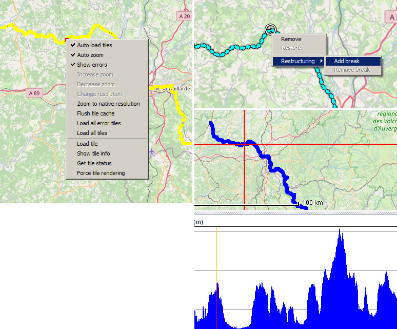
Edit2: The knife buttons seem to be disabled when you activate the OpenStreetMap view. They are enabled in the Preview.
Last edited by GerdP (2022-03-11 08:56:47)
Offline
#7 2022-03-11 09:07:38
- Shohreh
- Member
- Registered: 2012-12-15
- Posts: 247
Re: [JOSM] Show track elevation, and let user split track into sub-tracks?
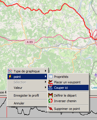
Found it: You have to right-click in the altitude window at the bottom, NOT on the track on the map.
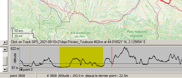
I wanted to slice a track into sub-tracks, based on 1) distance, 2) elevation, and 3) housing, so it had to be done manually. A bike day with high elevation has to be shorter than one with a flat road.
One useful feature found in GTE that GPX Editor is missing, is displaying each segment in a different color.
Two more questions, since GPX Editor's online forum seems gone for good (Dec 2020):
1. In GPX files, what's the difference between <trk> and <trkseg>?
2. Is there a way to change the language UI in Gpx Editor?
Last edited by Shohreh (2022-03-11 09:09:36)
Offline
#8 2022-03-11 13:54:56
- GerdP
- Member
- Registered: 2015-12-18
- Posts: 1,972
Re: [JOSM] Show track elevation, and let user split track into sub-tracks?
1. A single <trk> can contain multiple <trkseg>. Typically each segment contains a sequence of recorded points, while there can be large gaps between two segments. When I use "reset trip data" on my Garmin Oregon it creates a new segment.
2. I don't think that GPXEditor supports different languages.
Offline
#9 2022-03-11 16:09:43
- Shohreh
- Member
- Registered: 2012-12-15
- Posts: 247
Re: [JOSM] Show track elevation, and let user split track into sub-tracks?
Thanks. I'll read up about the differences between trkseg and trk to have multiple… parts into a GPX file.
It does (English, French, Spanish, German, Russian), but it might be hard-coded to use Windows' Regional setting.
Another feature missing from GPX Editor: It doesn't show the distance from the start (of the track/selection):
Too bad the author chose Delphi instead of eg. Python, so more developers could contribute.
Offline
#10 2022-08-07 09:50:20
- Shohreh
- Member
- Registered: 2012-12-15
- Posts: 247
Re: [JOSM] Show track elevation, and let user split track into sub-tracks?
For those looking for the same thing: Java application GpsPrune lets you select part of a track ("range") and see the climb + descent.
Unlike Gps Track Editor and GPX Editor, it seems unable to slice a track into multiple sub-tracks, though — it can only crop the currently selected range, and dump the rest.
Offline