part of the building larger than the building

Is it possible to map such tower?
https://fotopolska.eu/1221/1221509/10000/Wroclaw_Wieza_cisnien.jpg
https://wiezecisnien.eu/wp-content/uploads/2016/01/Wroclaw_Brochow_PKP_2013r4.jpg
The building:part (upper part) would be bigger than the building=.

Will it work?

Have a look at https://wiki.openstreetmap.org/wiki/Simple_3D_buildings , chapter Building Relations.

It doesn’t work…
F4map renders only the lower part and omit the building:part
and OSMBuildings renders only the upper part, hovering above the ground…

https://demo.f4map.com/#lat=51.1090324&lon=16.9849412&zoom=20
https://osmbuildings.org/?lat=51.10913&lon=16.98503&zoom=19.4&tilt=30
https://www.openstreetmap.org/relation/11233147

Most 2D maps and some 3D maps use only the shapes with a tag building=yes. That’s the outline. It should cover the whole area under the building.
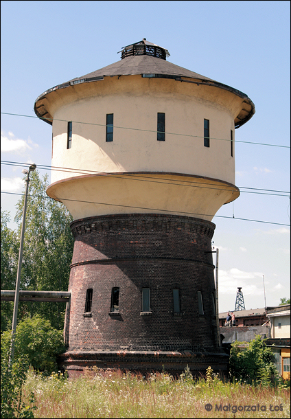
More advanced renderers use the shapes with building:part=yes. That’s the 3D shapes. Here you have just one. You probably want another one for the base of the tower.

Editing this is tricky; current outline is not an actual outline since it covers only the base, but making another shape for outline using the nodes of the upper part, moving just the tags, and using the old shape for building:part probably hurts change history.

In the past I did this as try out for 3D.
Perhaps make a ground base shape that you need for de max shape above and set it as building height=0.001 :slight_smile:

https://osmbuildings.org/?lat=50.78944&lon=3.14085&zoom=17.6&tilt=30
https://demo.f4map.com/#lat=50.7894385&lon=3.1408516&zoom=18&camera.theta=73.934&camera.phi=-1.146
https://www.openstreetmap.org/query?lat=50.78931&lon=3.14072

Looking at your relation, it seems you only mapped one building part. Going by the book, there should be three members of that relation:

  • the lower part
  • the upper part
  • the outline for the building as a whole (which e.g. should have the total height of the building).

Also, Simple 3D Buildings asks that the building outline should surround all the parts (rather than just the ground level footprint), but for a renderer that supports building relations, this should not make a difference.

Both 3D-maps don’t fully support Simple 3D Buildings.
F4map seems not to support relations and ignores building:parts overlapping the outline. See “Buildings & building:part” on https://wiki.f4map.com/render.

If you tag the outline with both, building=yes and building:part=yes together, OSMB should show it. But that’s not the way it’s meant to be by Simple 3D Buildings (as far as I understand it).

Because the outline part will be ignored (see https://wiki.openstreetmap.org/wiki/Simple_3D_buildings#Building_outlines: “When a building has any building:part=* areas, the building outline is not considered for 3D rendering.”), I added a additional part identical to the building outline but tagged (only) with building:part=yes and not with building=yes.
That’s the “lower part” Tordanik mentioned.
Let’s see if OSM Buildings eats this.
https://www.openstreetmap.org/way/820460678
https://osmbuildings.org/?lat=51.10913&lon=16.98503&zoom=19.4&tilt=30

It is just a typical tower? Seems do-able, but needs some additional non-standard way to hide the outline.
https://osmbuildings.org/?lat=1.35977&lon=103.98949&zoom=18.2&tilt=45&rotation=1
https://www.openstreetmap.org/way/738597392#map=19/1.35917/103.98928

Yeah, it looks like it works on OSMBuildings :slight_smile:

F4 doesn’t refresh often…

Thanks for this example, I will have a look at it.

F4map won’t show the upper part of the tower unless the outline of the building is at least as large as the parts. Thats’s the case with the example at Singapore Airport, JaLooNz hinted to.
What is the favoured outline? The footprint on the ground or the largest extent?

Simple 3D Buildings explicitly asks for the largest extent. I don’t think there’s a clear preference otherwise, although aerial imagery makes it easier to identify the largest extent than the footprint on the ground.

So basically you want to create something like this?
https://osmbuildings.org/?lat=47.82920&lon=13.05422&zoom=20.0&tilt=31&rotation=-47
Would love to give an example in f4map but its simply not working for me.

The base-area should include everything. The biggest extent of the building. And from there work with building-part and if needed, create a relation with type=building. Use min-height for example.