The fact that you don’t agree does not mean the arguments did not exist. Local (national) consensus is not wrong, it’s how we agree to do things for now in this country. If you do not agree, you can weigh in, but not dictator-style. Please refrain from further mapping in this way.
The biggest problem is your claim:
Anyone else acknowledges there are different types of constructions that are called aqueducts. Just read the first two sentences on the English Wikipedia page: “Bridges for conveying water, called aqueducts or water bridges, are constructed to convey watercourses across gaps such as valleys or ravines. The term aqueduct may also be used to refer to the entire watercourse, as well as the bridge.”
Sentence 1: Most aqueducts in The Netherlands don’t fit this description.
Sentence 2: Different use of the term aqueduct.
Cases where a waterway is created, raised or substantially altered by the construction of an aqueduct are rare in The Netherlands. The waterways are almost always already there. The roads are the ways that are constructed newly or differently. You could even called them ‘inverted viaducts’ because the roads are being ‘led’ more than the water. For the waterway there is only the change of surface from natural materials to artificial.
Maybe not for you but for most other people the objective and history of elements do help define what it is.
By the way, this is very common in OSM: highway=primary is about objective, waterway=river and waterway=stream are about history, and these are just a few easy examples.
Something else that you haven’t adressed:
For us a tunnel-tag on the road means that the infrastructural situation is tagged: the crossing of a waterway above a road or a road underneath a waterway. But then you get upset because according to you your ‘mapping of an aqueduct’ is made undone. For you the tunnel-tag on a road is optional but for us this tag marks the whole infrastructural situation called ‘aqueduct’!
LOL …
sometimes there are some morons on the exact words →
![]()
![]()
![]()
At least the Dutch translation aquaduct is the most correct … ![]()
https://nl.wikipedia.org/wiki/Aquaduct_(watergang)
De Friese spelling vind ik het mooist ![]()
oei… English thread I like the Frisian spelling at most
@Wyo: I hope you don’t stop mapping in the Netherlands, regardless the outcome of this discussion.
I hope that I would not have felt that as an accusation, but as a question that led me to evaluate my reasoning and conclusions and perhaps as an opportunity to show and explain to the people I’m discussing with that they misunderstood my arguments.
After giving it some thought I would guess that the problem lies with the bold marked section:
most of the the things called “aquaducten” in The Netherlands are often not clearly seen as bridges by the local community, and I agree with that, and I think the reason is, As Andries pointed out that these are not new waterways drawn over existing landscapes, by new roads that are led under existing waterways
But as an exception I guess most of us would would see this one as a bridge, since it spans 4 roads and two water areas (you’re right about that)
https://www.mapillary.com/map/im/Ep32f8lO1bH62knQ9UIMOg
https://www.mapillary.com/map/im/RnRQYHu0bG-BFCZfdjCjxg
(as a canoeist I do have time for pictures ![]()
With the bridge criterium not working for most aquaducten in the Netherlands there remains the criterium of “transporting some water above some air and something else” and in that regard the Dover-Calais tunnel (which I regard as a very different beast as well) is no different from aquaducten.
Personally I agree that Dutch aquaducten should be mapped in OSM as bridge=aqueduct on the waterway, but based on arguments formulated a bit differently.
The main aspect they share with each other and also the classical aqueduct between two hills over existing land is that the waterway is contained by an artificial, free standing ‘Flussbett’ (bedding).
In the case of the Netherlands the waterway might have already been there before there was an aqueduct, but in making the aqueduct an
freestanding artificial bedding replaced the original bedding (instead of digging below the waterway or sinking a tunnel tube for the road).
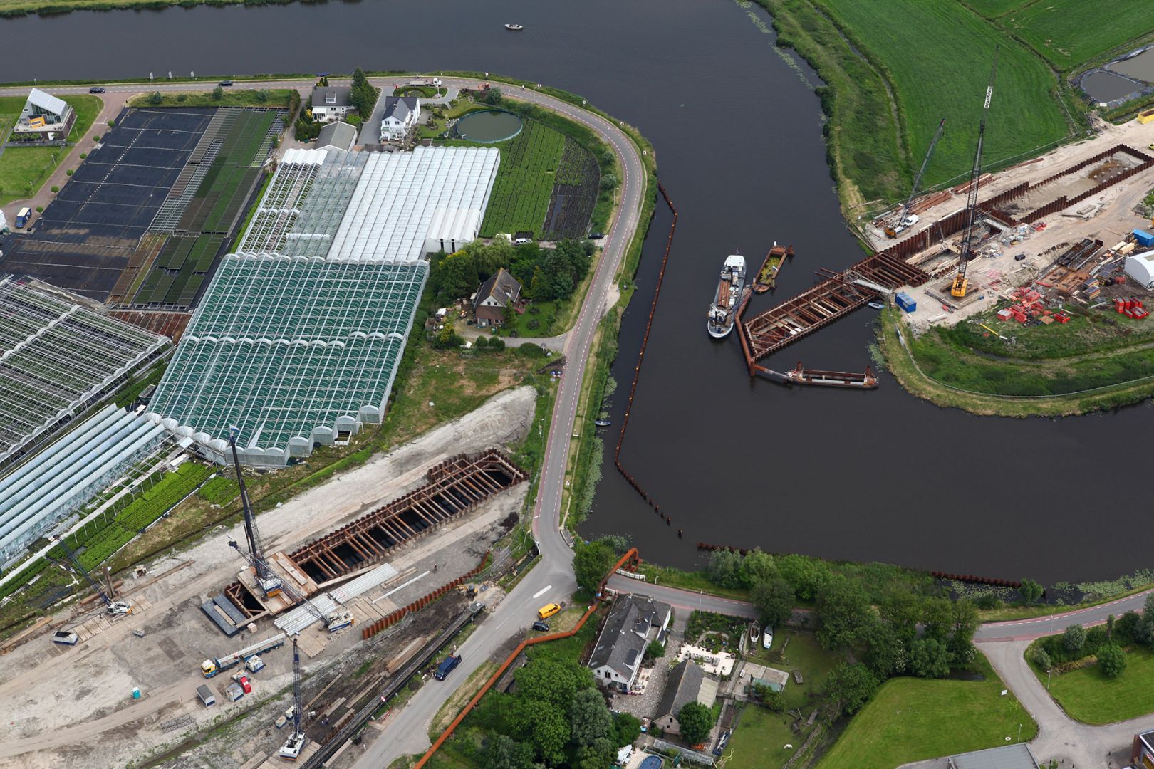
For example see from 10:15 in this time lapse of the construction of the Limes Aquaduct in the Oude Rijn (A4):
https://www.youtube.com/watch?v=OeC1YYanIxg
Or this animation from 2:00
https://www.youtube.com/watch?v=am0uPK9MnzE
The difference between a regular tunnel is generally visible both from the water and from the road.
But given the fact that the road goes down and under an existing waterway, I also agree with most Dutch mappers that a tunnel-tag on the road should be used.
I think the “Do however avoid using both a bridge tag for the upper way and a tunnel for the lower way for the same crossing.” should yield here. As you say, its not a strict law. Since the special circumstances and different perspectives of looking at aquaducten shown here, I think it shoud be interprted as “avoid when you can, but use if you must”.
For the (water-)ways that should solve it I think (if anyone finds the rendering on the waterway ugly, please make a suggestion at OSM-Carto).
The area’s are something else, still figuring some things out about that, but I agree with Andries and Peter that we should be carefull not activly doing things that cannot -with changes reasonably possible- be rendered properly and mess up our main map.
The rendering for a waterway with bridge-tag works as it should though: rendering a small blue line above the road. It just shouldn’t be used together with an area (natural=water).
You are willing to break the rule ‘avoid tagging both a bridge and a tunnel for the same element’ but also the general rule ‘one feature, one element’ is already broken by mapping a canal both as area and as a way. The latter may be accepted practise but then the same can be said about mapping a Dutch aqueduct as a tunnel for the underlying roads.
And what is the reason for accepting the combination of an area natural=water with a way waterway=*?
Is it not because the way normally doesn’t disturb the rendering of the area?
Yes, I think that the fact that it can be rendered without problems plays a role, but I think the principal reason -although not documented very clearly- is that linear elements are used to describe routable networks and areas to describe “landcover”.
With highways the linear elements are usually used for both, since we generally don’t mind ways being over-representated on the map, given how important we regard them (which shows ugly blanks after zooming in, I fully support tagging areas representing roads now that we have the sources).
You see some start with (normal) bridges being tagged as an area (man_made=bridge) while there is also a linear element for the highway across it with a bridge=yes tag
But I think nobody would propose deleting the linear highway-element after an more infromative area with “man_made-bridge” (with only that one highway) is added and the highway-tags are transferred.
Water tagging starts with either areas for the big lakes and linear elements as a quick and dirty fix for smaller ditches/canals, but routable (not necessarily navigable) linear networks are also formed, for example to describe how rivers relate to each other.
So I think linear and area representations of the some objects are commonly accepted next to each other, given their different goals and in area-tagging highways are just dragging a bit behind the waterways in this regard (-;
However the page for "one feature…"could have some additions to reflect this current usage.
Ik denk dat dit verder wel in het Nederlands kan.
I agree with your post. The thing is that just as we accept certain things for routing purposes (‘being pragmatic’) we could and should, I think, accept some things for rendering purposes. Because you could also say: “no tagging for the router! Let the developers of routing software find a way to handle areas!”.
I don’t see why a node on the waterway denoting the aqueduct wouldn’t be satisfying for routing purposes (a new seamark-tag for this would be nice).
-
Persoonlijk zou ik graag zien dat sommige areas routable worden. Dat zou voor voetrouting door een pedestrian are helpen, en path door een weiland of stuk heide, en waterway door een water area. Heel veel ways worden zo immers als dummy redundant getekend, alleen maar omdat areas zogenaamd niet overgestoken kunnen worden.
-
Je kan aan een lijn domweg niet zien wat het echt is, dus moet je aannames doen en extra tags toevoegen. Zoals het voorbeeld van de polderslootjes laat zien, is dat niet realistisch: afhankelijk van zoomniveau zie je bijna alleen maar water of bijna geen water.
-
Als je het water als area tekent, en het loopt door een aquaduct, zou je het moeten versmallen tot de echte breedte en zou taggen als aqu[e|a]duct betekenen: render de zijkantjes met een hard lijntje. Meer niet, toch? Of er dan een waterway overheen loopt boeit verder weinig, die heeft geen boodschap aan de zijkant. Vaargegevens zoals max diepgang moet je wel taggen op de waterway, maar dat moet je zonder aquaduct ook.
Als je ooit kan routeren over waterareas kan je ook daar de diepgang wel opzetten trouwens. -
Als er een weg onderdoor loopt boeit het voor de weg eigenlijk niet of hij onder water, spoor, olieleidingen of onder iets anders of helemaal nergens onderdoor loopt. Dus aquaduct hoef je niet op de onderdoorweg te taggen. En voor het aquaduct boeit het eigenlijk niet wat er onderdoor loopt of dat er helemaal niets onderdoor loopt. Je kan op dat stuk weg een tag zetten die het stuk weg het best beschrijft, zonder je druk te maken over wat eroverheen loopt. Is het iets met dichte/harde zijkanten, dan graag over die lengte een mooi hard lijntje aan de buitenkant van het wegtracee.
Tunnel als het duidelijk een tunnel is of tunnel genoemd wordt, tunnelbak als het grotendeels open is behalve waar het aquaduct oversteekt, en een passende andere kreet als het nog iets anders is waar je echt met tunnel/tunnelbak niet wegkomt. Niet gemapt, dat is dan een tekort op de kaart maar er gaat niks fout.
Als je het stuk weg waar het aquaduct overheen gaat maar geen aquduct, viadukt, spoorviadukt of bridge gaat noemen, lijkt mij.
Okay lets discuss the Calais-Dover situation seriously:
- Any air on top of the road belongs to the tunnel, there’s no single strip of air which belongs not to the tunnel
- It is named “tunnel”
- On the water there’s no visible hint that one is passing on a bridge
Summary: 3:0 This is a tunnel and no aqueduct
- Amstel acuaduct
- There’s no air not belonging to the tunnel
- It is named “adeduct”
- A bridge might or might not be visible on the water
Summary: 1:1 Problably a draw meaning tunnel=yes and aqueduct=?
- Leeuwarden acueducts:
- I don’t know if there’s some air which doesn’t belong to the tunnel I assume not
- It’s named “awadukt”
- It’s clearly visible as a bridge on the water
Summary: 1:2 meaning tunnel=yes and bridge=aqueduct
- Mid-Fries Aqwadukt
- There’s lot of air not belonging to a tunnel (neither motorway nor cycleway), it’s not even visible as a tunnel but a bridge
- It’s named “Aqwadukt”
- It’s clearly visible as a bridge on the water
Summary: 0:3 meaning tunnel=no and bridge=aqueduct
- Prinses Margriettunnel
- I don’t know if there’s air beside the tunnel
- It’s named “tunnel”
- I don’t know but suspect it’s visible as a bridge
Summary: Probably 2:1
This is so far the only case where it’s not clear what should be mapped. From the road aspect it’s obvious a tunnel and not an aqueduct while from the touristic aspect it’s a tunnel and an aqueduct.
The difference to the Leeuwarden objects aren’t that different. I probably would map it equally. Same goes for the Mid-Fries Aqwadukt or similar objects, a tunnel=yes is acceptable since people might think of a tunnel.
New or not doesn’t change anything on the definition of aqueduct, transporting some water across some air. New is only that there are passing some other things with the water. Locale people using these objects on a rather daily basis don’t care what these objects are yet foreigners do. I prefer mapping for people not used to a local situation.
Isn’t this the same question as “Why is it accepted to map roads on amenity=parking”? Do you also question this https://www.openstreetmap.org/#map=19/52.95912/5.92720?
Breaking?!? “avoid” does not mean “may not”. This rule was made with situations in mind where multiple ways were surpassing by one or some few ways, e.g. a railway field surpassed by a road. The situation with aqueducts are completely different, a single way is surpassing by some few ways. Taking the count of ways into consideration, a bridge has precedence over a tunnel yet since both are similar counts it’s acceptable map both.
I don’t see the need for any precedence of one over the other. I agree that it’s acceptable to map both in some situations, especially if they have consequences for both waterway users and road users. The only thing not really acceptable is mapping nothing if there clearly is something worth while!
Currently, lots of structures are like open tunnels, “tunnelbak”. The concrete walls of the road stretch way beyond the bridge/viaduct/aquaduct go over it. Sometimes they support the structure, sometimes not (as multimodaal’s aquaduct pictures, which happen to be taken about 500m from my house).
Do we have a tag for that? If not, I would probably use tunnel, if it’s in any way relevant for people using the road. Otherwise I would not tag the road.
@Wyo thanks for the examples and comments.
Although I agree with you that all the examples except the Calais tunnel are aqueducts (not sure either about Amstel) that deserve a bridge=aqueduct on the waterway, I can’t understand the argument “air not belonging to”.
Do you mean the rounded walls seen approaching the aqueduct from the road up close?
For me it depends on the point of view, from a greater distance I don’t see a bridge, but the road lowering below ground to cross the aqueduct
I guess when the waterway is new it is an aqueduct by definition, because the bedding is artificial and freestanding.
When the waterway existed before a road crossed underneat, it can be either an aqueduct or just a tunnel.
I agree with all the cases you call aqueduct and also think that the Princes Margriet Tunnel is actually an aquduct, just like
https://www.wegenwiki.nl/Prinses_Margriettunnel
(don’t trust our names, what we call Maas at Rotterdam is actually Rhein for the last ten? centuries… ![]()
The reason? Even if might it is perhaps not visible from the water looking north, it appears to have an artificial freestanding concrete bedding instead of a tunnel dug under the original bedding
@Allroads pointed to this interesting link in this post
https://bezoekerscentrum.rijkswaterstaat.nl/SchipholAmsterdamAlmere/waarom-aquaduct-muiden/#.W9elQmhKibh
The national road authority explains, from the water perspective, why this -despite its length dfrom the road perspective- is an aquaduct instead of a tunnel:
Their use of this criterium is good enough for me, sounds logical and saves a lot of discussion.
Sometimes though I guess you have to look at how the structure was built when it’s not clear from the end result, like at the Amstel Aquaduct. And after that it seems to me that -after first doubting that, looking from the road alongside the water- the name is apptly chosen after all, even if it is really not a typical aqueduct, especially looking from the water, but I guess that’s a compliment to the builders in preserving the “natural” feel of the waterway:
(on second thought: the “freestanding” isn’t so obivious here, arrgh…)
https://aerovista.nl/langlopende-projecten/
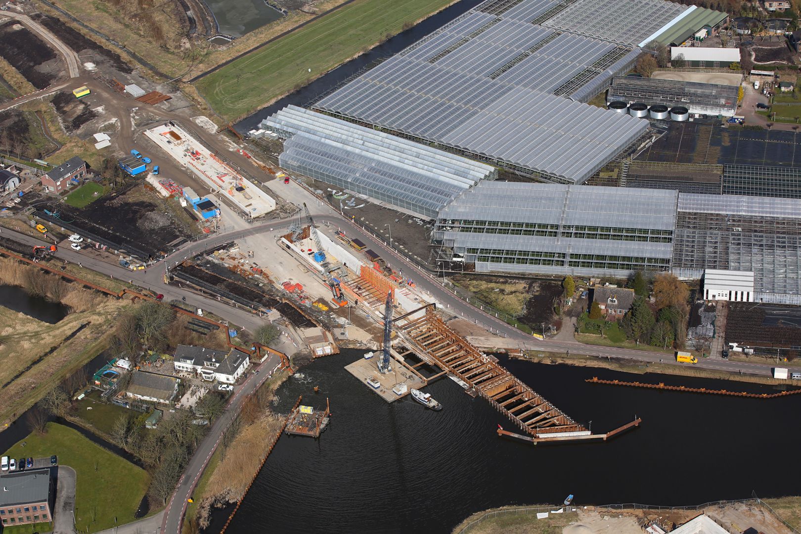
https://www.mapillary.com/map/im/Dsq-_8rDiDAGYuLA7da7bg
No. Roads are real objects in a parking area. Waterways are fictional lines in a water area.
But I do accept the importance of the lines for routing purpopes. It’s wouldn’t be reasonable for me to expect that routing software can find a logical route through an area without that additional information.
Routing is one of the major uses of OSM data. But certainly not more important than rendering maps. We should take rendering in consideration when mapping.
I’m not sure what your argument is with counting of ways. And of course there are no hard rules.
But just as you think that this rule or guideline was made for other situations than aqueducts… I think that the tag man_made=bridge was or is not yet intended for aqueducts and the tag bridge=aqueduct was intended for waterways but not when there’s also an area mapped for the water.
![]()
Dutch people seems to have some special sense for names.
Very interesting link, thank you.
When mapping I always take the impression of the users of the map into consideration. When someone drives on a road into something like a tunnel it would be nice to give some advanced warning of having time e.g. to remove the sunglasses. Similar for driver on the waterway to get enough time for taking pictures. I for sure will once drive across the aqueduct near Muiden and see how it looks and feels, of course only after I’ve found it on the map.
What about ferry routes? Are these also fictional lines in a water area?
We should look at the structure and not at the impression that it gives. It is called “infrastructure” and not “infra-impression.”
Btw, I thought that you were on the bridge side of the story.
This topic will be closed as this is a Dutch language sub-forum.
What I do no appreciate in this thread is the high frequency of postings, repeating opinions, not listening to others and being too self-convinced.
To Wyo I would advise: respect how Dutch mappers tag Dutch aqueducts in Dutch landscape (flat); they have the reasons for that. You might disagree, but democratic principles rule.
On request, this topic has been re-opened…