OK, following a personal email from Stephan I’ll attend any meeting with a view to moving forward. I hope that if the Thai mappers can come up with a clear set of instructions to the DWG, maybe we make can some progress.
Everything Tom & Peter say comes from the same heart as me … when we map, its as a human, looking logically at the road network. This is what dedicated OSM mappers like us did … see something wrong, or something that was missing with every new set of aerials … we added it. Smooth a curve here, straighten a road there … continual improvement. The FB team just banged it in, and moved on. Eventually the sheer volume of “tidying” FB inputs was just too much … we never stood a chance.
I note we are being self critical over our local definition of road vs. track … Peter is right… if in doubt, downgrade it, and revert later when better evidence comes to light.
My biggest issue with FB is that clearly they do little to correct the existing map when they import … you know it makes sense if, when you draw a road, take a quick look at the adjacent roads and see if with a few more additions, navigation would make sense, and through routes would be created.
I have always criticised FB from this angle, and once you see a nest of FB imports, there is a tendency to move on … its heartbreaking to see it, and a waste of time to start editing it.
And by way of a real example, I was driving down to Kanchanaburi last week, and noticed a lot of U-turns missing on Hwy 340. I know that in the early days, the aerials were poor and a lot got missed, but in Thailand, passing the road you need and doing a U-turn is fundamental part of the driving here. I vowed to correct on my return…
Oh yes, Facebook got there first, and I thought, well lets just log what “sloppy” mapping I notice, and it didn’t take long to fill a page:
Chai Nat :
Way: 527960964 - VLD007 added many residential roads either side of the Trunk Hwy but completely ignored the link roads (U-turns) that are necessary to turn into them.
Way: 528184019 - VLD007 draws a long road as a residential despite fact its clearly unpaved, and only passes one farm, but then fails to draw the bridge at the eastern end. This should be a track, or at the very least, get an unpaved tag.
Way: 527984298 - Ditto the above, but it doesn’t even pass a single structure once leaving the asphalt road.
Way: 527960922 - The residential road is drawn, but then no attempt has been made to clean up the poorly drawn junction it connects to… the one with the fixme=precision tag clearly visible. Its also unpaved, but no tag was added.
Way: 527963823 - Does the road really need this many nodes in the curved area ? It can’t be like this in real life? I would smooth out, deleting surplus nodes.
Way: 527960904 - The way connects to Hwy 340 Eastbound carriageway, but not the Westbound when clearly there is a U-turn gap in the median to do this.
Way: 527922341 - Again, Im guessing FB automated software picked up the residential road, and VDL007 connected it to the Southbound carriageway. There is a U-turn link that connects it to the Northbound but he was either too lazy or simply blind and did not draw in the link. Its errors like this that makes GPS navigation useless.
It’s just the whole “bang it in attitude”; roads are split in random places, ever heard of the merge command, FB ? And crossroads are a rarity to them … take a look at the number of residential roads where the connection is clearly a crossroads in reality, but FB just goes with wherever their automated system puts the node… even if its is only 5 mtrs offset. So whats the issue ? I’ll tell you, my GPS says “turn right, then turn left” and then I’m heading down the wrong road. But then they never ride here, and with a “successful OSM project finished” on their resume, off they head to another posting.
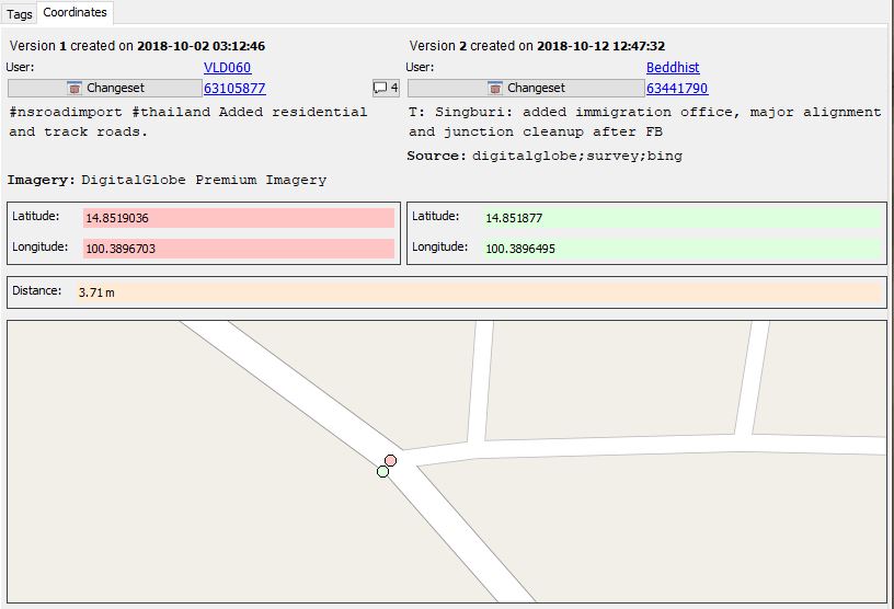
And so with heavy heart, they say “we are really concerned, but VDL whatever has left us now” … OK, if he was that bad, revert every one of his edits. Some of these date to 2017, so clearly going back and putting things right doesn’t seem to be working. Few changes are taking place.
And while I’m on the subject, ask VLD012 why he changed Way 383032616 from track to unclassified road (without even adding the unpaved tag). The imagery shows this goes through a forest, is unpaved, and runs steeply through terraced rice paddies. Chris labelled it a track for a reason, and I humbly apologise if VDL visited and its been asphalted since … but go on, prove me wrong. We don’t change existing data they say … more meaningless words.
The way forward … well I cant make bulk changes, I dont have the skills, but we should start taking control of the Thai map back … lets downgrade the short roads as Peter suggests, lets convert FB residentials to unpaved alley, until we can verify differently… lets convert all FB import=yes residential roads in the countryside, to unpaved.
When I started complaining about FB, I was a lone voice … I see Tom & Peter now following suit. Frederick of the DWG is correct; we never gave them any clear indications of what was wrong and what to do. As Thai mappers, we should meet and at least see if we reach a unanimous way forward.
We can do this, if we want to … lets not stand by and do nothing. You know, maybe we don’t even need the DWG involvement. I’m sure they will be happy if we make our own corrections locally. I certainly don’t think speaking to FB is any good, given the poor responses to date … it OUR BABY I’m afraid.
Rgds, Russ.