Anyone have any idea how to get from this:
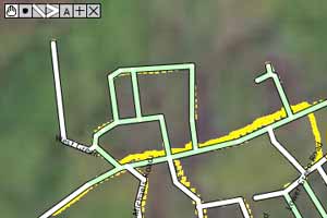
to this:
(On the first image my lines aint white either)…there just all green…
P.S Im not asking for road directions by the way!
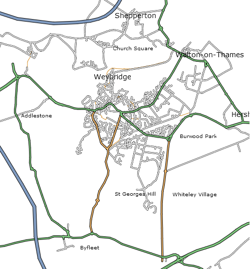
Anyone have any idea how to get from this:
to this:
(On the first image my lines aint white either)…there just all green…
P.S Im not asking for road directions by the way!
Well, there is a lot of steps really, the first being making ways, and then tagging them with reference to the Map Features list.
http://wiki.openstreetmap.org/index.php/Editing helps a lot. The map you provided was made with Osmarender.
Thanks. I’m having great difficulty still though. If I wish to apply way properties to many segments at a time, i seem to not be able to get the options bar pop up.
On the list of road types, im not shore what the difference between a minor road and an unclassified road are…
Also what would gated roads count as?..minor?
I read those pages a while ago, but i was really wondering if this could be done in the offline editors, cuase the online editor drives me nuts.
You are supposed to select the segments, create a way out of them, then tag the way with properties.
JOSM is definetly the best way to contribute, and it does ways. There are some tutorial videos here - http://www.eigenheimstrasse.de/josm/tutorials/
hmm, slowely getting it… Cant get those videos working, aint got/don’t know what codecs are needed, and i aint got a clue what a .ogg is.
OSM editor confuses me greatly. I open it, and if i open files it has a strange ply effect. What is the address to try downloading data from?
OGG is a free container format, WMP can play them if you install these Directshow Filters for Ogg Vorbis, Speex, Theora and FLAC
Is this with JOSM?
cheers for the codec link, those videos are really really helpful, there were some cool little things i didnt know of
I relise my problem with the new ‘way properties box’… it just vanished behind pages, so i lost it…!
Im left thinking that that high quality rendered map above, looks that quality because of the softwear that displays it, rather than than additional data being attached to it…?.. I have got roads with names and colours now anyway.
Im still not quiite shore how attaching an area wich is a woodland for example is posible. i.e. creating properties to something between vectors rather than to the vectors themselves. Signs such as churchs/Post offices etc, also leave me a bit puzzled.
I was talking about OSM editor, not JOSM in the above post.
You don’t just yet, there is no support for areas, Etienne has been working on a beta version of Osmarenderer to do this for you in a hacky way. But I think you might rather want to wait a while.
http://article.gmane.org/gmane.comp.gis.openstreetmap/4211/match=chertsey
cheers for that.
Leaves me confused why Osmarender and JOSM are two seperate programs. Are they written by the same person?, and do they not both just allow you to edit the data.
I think the plan is to have an online interface to Osmarender. Osmarender is written by 80n, and JOSM is Imi.
JOSM is made by me. Osmarender is done by Etienne. While JOSM is for editing of data, Osmarender is to translate osm-xml files to a nice svg-map. You can’t edit data with Osmarender.
Ciao, Imi.
ooo, That makes sence, thanks. Really Good video tutorials by the way imi
Alternatively, the VLC media player (open source (GPL), cross-platform (Windows, Linux, Mac and others)) seems to handle everything I’ve thrown at it.
Yes, I was going to suggest that.
On a slightly offtopic note, the Ubuntu Forums has a mailing list section, did the extention not work here?