The reference number of rural roads starts with the abbreviation of a changwat. Currently, we think that it is the changwat we find the sign or milestone with that reference number. I want to challenge this:
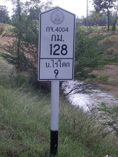
กจ.4004
This photograph was taken in changwat Phetburi:
It shows Kanchanaburi road number กจ.4004
The kilometer number 128 fits well to an origin in Kanchanaburi province.
This sign is rather new, also a blue DRR sign somewhere else on this road is rather new, thus indicating that this number is currently used here.
Note that you must cross Ratburi province to get from Kanchanaburi to Phetburi.
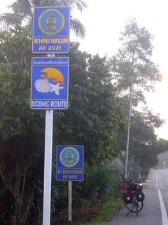
สส.2021
That’s a somehow different beast:
Typically, the milestones on the road show the reference number สส.2021 of Samut Songkhran, the blue DRR signs are often accompanied with a sign for a “scenic route”, and in some places it is called “Royal Coast Road”.
I found it in Phetburi, Prachuap Khiri Kan, and Chumpon provinces, typically with a high number for the road kilometer.
But then there is that extra road number encountered in Chumpon, as shown on the picture.
I thought สส.2021 could be the reference number of a route instead of a road. But I am not sure how things look like in its province of origin.
Have you also encountered such strange road numbers?
How can we deal with them?
I cannot shed any light on this problem except to say if you hope that Thai road names/route numbers would be consistent, you are not alone. I’m subscribed to this thread and will be interested to hear what comes out of it.
Is this solution workable? I suggest it more or less as a humorous counterpoint.
Funnily, this thread comes just a week short of one year after this one, which mainly discussed the number part of the refs.
Apparently, there are quite a few DRR roads whose refs (prefix & number) span multiple provinces. More precisely, they’re under the authority of multiple provincial rural road offices/bureaus—there are others still that cross a little over the actual provincial boundaries but remain under the care of their “home” office, but that is not the case here. กจ.4004 appears three times in the DRR’s index, under Kanchanaburi, Ratchaburi and Phetchaburi. You can try searching for “(ตอน” in the PDF to see other roads that are likewise split among multiple offices.
สส.2021/ชพ.5015 is indeed weird. The index does say that สส.2021 is split, but only between the Samut Songkhram and Phetchaburi offices, and it’s supposed to run only as far as Cha-am in all versions of the index since 2012. But the sign in your photo looks quite new. And I found this thread on rotfaithai.com, where the poster asked the same question back in 2014. So it’s not a recent change either.
Anyway, the royal coast road appears to be a long-running project of the DRR. However, I couldn’t find any documentation that says สส.2021 is the ref for the project. The DRR’s website has a series of tourist guide articles describing the route at www.drr.go.th/coast, but all of them label the roads with various local refs (which actually seem outdated, since พบ.4012, 4028 and 4033 have all since been merged into สส.2021).
But then I found this 2013 PR piece from the Chumphon DRR office reporting a community meeting during the impact assessment for the construction of a new section of the coastal road, and it referred to the route as สส.2021. So my guess is that the Chumphon DRR office somehow regards สส.2021 as a ref for the entire route, and uses it as such. The new section hasn’t yet appeared in the central DRR’s official index though, leaving many questions. But for now I’d regard this as an isolated case and blame the local DRR office for the inconsistency.
But what to do with that สส.2021?
In Phetburi province, I marked some waypoints on my GPS for this reference number. But I did not change the reference number which is currently in our data (e.g. พบ.4028 https://www.openstreetmap.org/way/341130546). I think I should update that to สส.2021.
And that section in Chumphon province? The สส.2021 sign looks newer than the Chumphon sign…