Dear friends, after data validation in Erlangen Germany I realize:
there are a lot of buildings like this: http://www.openstreetmap.org/way/31363495#map=18/49.58551/11.00845
and 3D mappers avoid tagging of such buildings. The situation as in the above example, occurs unfortunetely often.
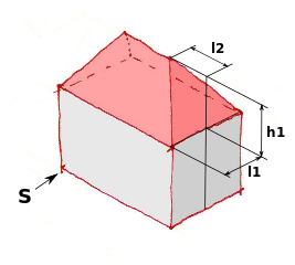
Personally, I would be in favour of treating this as a special case of the “hipped” roof. In this image of yours, you mention a parameter “l2”:
If we were to define a tag for this parameter, then we could map the roofs discussed here by setting the parameter to 0. As an additional benefit, we could also map all the cases in between, which wouldn’t be possible by defining 2 roof types for the extreme points.
I think we could name it like side_hipped_left and side_hipped_right with direction tag set. It will be easier to use single tag for roof shape, then defining some l1, l2 parameters. Of course that parameters could be used as option.
This example is obvious. Unfortunately we have situations with buildings like this: http://www.openstreetmap.org/way/248981926
Bing background is bad, but this singular building has exactly the roof shape of which I spoke.
And sometimes are the neigbour buildings of fuly different geometry
How such roof type comes?
Sometimes is one of buildings which stand in a row removed, because of fire, age or because the owner wish onne new buildig: more modern and higher.
In such cases we have often this kind of roof.
Also new extensions to existing buildings have often this roof type.
I’m not sure that it’s “easier” to use a single tag. If we invent lots of different roof types, even for roofs that are just variants of existing types, then finding the right one becomes a challenge in its own right.
@Tordanik
So the hard question is how to name that l2 parameter? Because it definitely can’t be named l2. The only idea I have is to call it like “rightHippedLength” but it is little complex…