If i upload my changes with help of JOSM, then i assume there is no need for me to upload the saved .gpx-file via the upload applet?
Can i see my pending work someware, or do i just wait a few days to see my data add up on the map (http://www.openstreetmap.org/index.html) ?
Do i need to specify intersections somehow in JOSM, or will any two roads crossing each other be treated as having an intersection?
If you want to keep your GPX files private is entirely up to you, there is no need to make them public. However, your GPX files combined with other GPX files from other mappers will eventually help in getting the tracks more accurate. So if you do not have any privacy or other objections, then please make your GPS tracks public.
About viewing the results of your work: There is a special map where you can request the map tiles covering the area that you have worked on (as well as any other area ofcourse) to be rendered again. Usually the new map tiles will be available in about 30 minutes after requesting them but as you might have noticed, OSM servers are having some problems with the rapid growth of the community and the new software on the servers is still a bit buggy. So unfortunately this service is not functional at the moment (you can view the map though). I expect it to become available again somewhere this weekend or so.
If a physical intersection exists between two ways then you have to put a node into one of the ways and connect the other way to it. This does not apply to ways crossing eachother via a bridge or tunnel of course, these ways simply cross eachother and one of the ways has a special segment defining it as bridge or tunnel accordingly (perhaps even with an aditional layer tag when intersecting roads get complicated e.g. multiple levels).
You definitely should upload any GPX files you base any OSM data off, this means we have evidence of the data being derived from GPS traces as opposed to copyrighted sources. It also allows other mappers to benefit as Lambertus said above.
Thank you for the information.
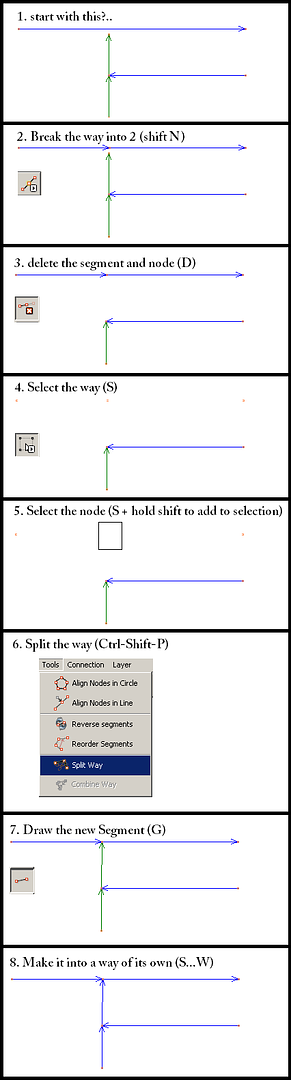
In JOSM. I did not figure out how i can connect a nod from one road onto another road to create an intersection without removing the way and working with the segments.
Is it possible somehow? Can you help me by providing a small step by step guide to an intersection like this?
to:
—X----road 1 (way) -------------
|
|----road 2 (way) -----------
where X is the added intersection.
“way” is a way made from many segments.
thanks again
k_b
garmin etrex vista cx
By the way, is it possible to hack or change the firmware on the vista cx to add easier marking of waypoints?
It’s not very easy pressing and holding the rocker for 2 seconds when riding a bike.
I’m not completly clear what you want. If you don’t want to change road 1, except for having a node on it, then insert a node (shift x). If you want to split the way on a selected point and get from your first diagram to the second then I would do the following.