This is not only a problem with your request, but a generic toolchain problem. The harddisk full problems earlier this week caused the toolchain to be broken. I hope it’s fixed again.
Lambertus, thank you once again for this service. It is fantastic. I use it in Australia and find it as good if not better than the commercial products.
The ability to correct errors on OSM and see them rectified a day or two later is fantastic.
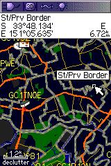
One issue I have found with the maps is that they render a particular (unique) setting as a thick purple line. This makes the map confusing to read. It is a set of lines used to define the boundaries for suburbs as defined by the Australian Bureau of Statistics. They include the following attributes:
Is it possible to adjust your settings so that lines are either thin light grey or invisible?
FYI - screen shot below. Purple lines appear light grey in this image. You’ll also notice they show up as St/Prv Border.
hello, thank you for this service. the problem is that streetnames contains some badly translated (national) characters. is this a problem of mkgmap or it can be fixed in your scripts? thank you, jose
Garmin uses different kinds of character encoding in different products. Afaik there is no solution to build one map that suits all those devices and applications. I choose to use the international name first, followed by the English name etc. in an attempt to keep the map readable for as many as possible.
Perhaps one day it will be possible to generate maps for specific devices and languages, but not shortly.
i have not transferred the map to a garmin device yet, just opened it up in MapSource. is there something i could do in order to improve the national character support? thanks, jozef
UPDATE: and it’s the same when i open the map in QLandKarte GT
Can you provide some examples? E.g. on the OSM map…? It could also be an mapping error.
will do tomorrow. in the meanwhile is there a chance to see exact commands that are being run on the server? you can send me a pm if it’s not for everyone’s eyes. thanks, joe
ok, changed my mind - i’ll explain today. please compare generated map opened in mapsource: http://img229.imageshack.us/img229/9653/mapsource.png or qlandkarte gt http://img259.imageshack.us/img259/6805/qlandkartegt.png (problems red underlined) with the actual situation on osm http://osm.org/go/0Lklwk–?layers=0B00FTF
the export will be available at http://planetosm.oxilion.nl/~lambertus/garmin/routable/23-07-2009/f8c62c9d2bbcddbf03e8d2e235e9e9ed/ until it’s deleted.
cheers, joe
How I generate the Garmin img files is no secret (I’ve posted it to the Mkgmap dev mailinglist a while ago too):
The gmapsupp and overview TDB+IMG file are produced when a user requests them:
This is a generic problem with making Garmin images, others have difficulties with code pages as well.
Hi Lambertus,
first of all I’ve to thank you for this great service, I really appreciate it.
I just requested a map of parts of Europe (unfortunately some tiles are markes red) and reveived email with download-link(s).
As a Mac-user I only need gmapsupp.img for my GPSmap 60 CSx and RoadTrip .gmapi.
This time the RoadTrip file is only about 1/20th of the Garmin-Installer and 1/30th of the gmapsupp.img.
Is there something broken or is it because of missing (red) tiles?
I think the RoadTrip script is prone to failure when trying to build the installer with missing tiles, so its probably better not select those red tiles.
*Even better would be to handle missing tiles in the RoadTrip script properly ![]() *
*
hi lambertus, thank you for the scripts. when i remove --utf8 and change code-page from 1252 to 1250 i can see correct characters both in qlandkarte and mapsource. i will hopefully have a chance to test it with etrex next week. is there a chance that you could create a selector for codepage and charset so user could modify the output?
kind regards,
joe
Thanks so much for these maps. It’s great to have free routable Garmin maps. Whenever I route to a location using the car/motorcycle setting, I’m routed through pedestrian pathways that a car cannot drive through, showed by a dotted line on the map. Is there a way to avoid these? Thanks!
If it happens everywhere on the map, its probably something on your GPS set up.
Assuming your GPS is set up correctly, and the problem occurs occasionally, I have these problems on non OSM maps when a road is mis-classified or a node is unconnected. You should check the route on OSM to be sure the nodes on “primary routes” are properly connected. Since road classification on OSM dictates the way they are rendered, it seems unlikely that a road would be rendered separately from its classification.
I’ve added some countries that are requested most often to a dropdown box. I hope this will eliminate many of the small differences in tile selections (but as a result they are unique requests) and relieve the processor a bit as it is at 100% almost 24/7 trying to keep up.
Startpost is also updated with the latest info.
Edit August 27: The country selection box works surprisingly well. CPU usage only spikes now and then instead of hogging the 100%. I’m starting to think about new features again ![]()
Hi
I download one part of your routable worldwide map for Mac
I got the Mac installer for Roadtrip, the installation runs perfectly…
But when I try to transfer the map to my GPS Garmin unit, the map is not transfered… It appear like a basemap…
I have other maps in my roadtrip and I can upload them without any problem to my GPS Unit
I also try to transfer using direct mapInstall… the same… all the installation procedure goes through, my GPS unit switches in “Transfer mode”… thn as soon as the stransfer is done… the map doea not appear in the GPS Unit…
Any advise?
Thank you
And the map shows fine in RoadTrip? Can you post a link to your map request (from the email). I have no idea atm.
CdM,
is this not a Garmin issue? Don’t know which type you’ve got, but the map should be visible in the folder Garmin on your GPS.
Can the first new feature be letting Canadians (and those from other countries, of course) experience these maps that we’ve only been able to read about lately? Please. ![]()
Regardless, your hard work is much appreciated.
The difficult part of trying to deal with the problems in Canada and the USA is the sheer amount of data involved and that I cannot perform tests on hardware that is under my control due to lack of memory (my laptop has 4GB which isn’t enough). Therefore splitting is done by someone else with access to a beefy university server. It is difficult to do debugging and testing through the hands of someone else.
So the (not so) funny thing is that I can add more types of maps or other features more easily than addressing one of the biggest problems with the current setup.
However, the source of the problem is found and already fixed in the latest splitter versions. I’m trying to get this new version into action, but testing takes long (a single cycle often takes longer then one day). But I expect to be able to provide maps for northeast USA and Canada soon, maybe not updated every week but we’ll see.
The second thing I’m working on is a webpage that can be used as a tool for splitting up problem areas and thus produce new configuration files for splitter. This will make it easier for me to fix the red tiles in Denmark and anywhere else they might popup. This is also made possible by recent changes in splitter.