You probably entered a wrong email address. Please try again after about one day if you did not receive the download email.
This is a known bug (see the start post of this topic). I hope to start working on this later this month.
You probably entered a wrong email address. Please try again after about one day if you did not receive the download email.
This is a known bug (see the start post of this topic). I hope to start working on this later this month.
Someone asked me about usage statistics of this service, so I pulled the logs and did some analisys.
Since the end of April 2009:
9200 map requests were made (~100 per day on average)
4800 unique email addresses were used (~50 requests of truly unique visitors per day on average)
Top 10 of requested tiles:
63240067.img 1374
63240069.img 1314
63240074.img 1313
63240080.img 1288
63240073.img 1274
63240075.img 1254
63240072.img 1253
63240077.img 1239
63240107.img 1236
63240065.img 1229
So the most requested tiles are in the south of Germany on the borders with Switzerland and Austria.
First North/South American tile is in place 125.
Edit: Some other statistics
Bandwidth usage is about 15 to 20 GB per day
Average download size is 64MB
This translates to ~220 map downloads per day
The server harddisk got at 100% full again this weekend. About 20 requests failed because of this. If you cannot reach the URL that is given in the email then please request the tiles again. Sorry for the inconvenience…
PS. Delete any “<” or “>” characters at the beginning or end or the URL in your browser if the server returns ‘404 Not Found’ and try again. If the browser then still returns the error then you will have to request your tiles again.
I’ve added a rewrite rule to the .htaccess file to automatically remove the trailing ‘>’ character from the download URL. This fixes a lot of problems for people who are using non-standard-compliant email clients.
RewriteRule ^(.+)>$ http://planetosm.oxilion.nl/~lambertus/garmin/$1 [R=301,L]
I’ve tried to request some tiles using 3 different email accounts but I haven’t received the email confirmation for none of them. Do you think it has anything to do with the recent change?
Thanks for your work!
I think the service has been mentioned in some newsitem or large forum in Italy as there are loads and loads of Italians requesting maps. The server is working as hard as it can to produce them but there is a backlog of about 100 requests. I see your username in a few of them so please be patient, it all takes a bit longer then usual at the moment.
All,
Not strange that the Italians are requesting maps: they have organised a major mapping party in the Dolomites. ![]()
I can’t go but else I would have requested one my self, Hugo
Ah, that explaines. Well, if they’d all requested the same area then that wouldn’t be a problem as the service would immediately send the email with an already cached combined map.
Unfortunately this night the harddisk got full again, so some requests have failed. If you get a 404 error when trying to get your map from the server then you need to request the map again. Sorry.
Lambertus, Thanks for all your work, it’s really a great site!
Since the last to map updates I noticed the nice icons on highway: motorway to secondary. In NL they include the road category and number, unfortunately in Germany only the starting letter is shown in this sign and the number is displayed bellow. I guess this is related to the space between letter an road number?
Thanks,
Thanks.
Yes, this is because of ‘the space’. This is solved in a newer version of Mkgmap, so when I update it the roadnumbers will be correctly displayed in Germany as well.
Today I requested a map. But there is no mapsource installer included (not even an empty .exe file).
This is not only a problem with your request, but a generic toolchain problem. The harddisk full problems earlier this week caused the toolchain to be broken. I hope it’s fixed again.
Lambertus, thank you once again for this service. It is fantastic. I use it in Australia and find it as good if not better than the commercial products.
The ability to correct errors on OSM and see them rectified a day or two later is fantastic.
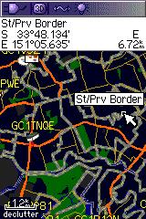
One issue I have found with the maps is that they render a particular (unique) setting as a thick purple line. This makes the map confusing to read. It is a set of lines used to define the boundaries for suburbs as defined by the Australian Bureau of Statistics. They include the following attributes:
Is it possible to adjust your settings so that lines are either thin light grey or invisible?
FYI - screen shot below. Purple lines appear light grey in this image. You’ll also notice they show up as St/Prv Border.
hello, thank you for this service. the problem is that streetnames contains some badly translated (national) characters. is this a problem of mkgmap or it can be fixed in your scripts? thank you, jose
Garmin uses different kinds of character encoding in different products. Afaik there is no solution to build one map that suits all those devices and applications. I choose to use the international name first, followed by the English name etc. in an attempt to keep the map readable for as many as possible.
Perhaps one day it will be possible to generate maps for specific devices and languages, but not shortly.
i have not transferred the map to a garmin device yet, just opened it up in MapSource. is there something i could do in order to improve the national character support? thanks, jozef
UPDATE: and it’s the same when i open the map in QLandKarte GT
Can you provide some examples? E.g. on the OSM map…? It could also be an mapping error.
will do tomorrow. in the meanwhile is there a chance to see exact commands that are being run on the server? you can send me a pm if it’s not for everyone’s eyes. thanks, joe
ok, changed my mind - i’ll explain today. please compare generated map opened in mapsource: http://img229.imageshack.us/img229/9653/mapsource.png or qlandkarte gt http://img259.imageshack.us/img259/6805/qlandkartegt.png (problems red underlined) with the actual situation on osm http://osm.org/go/0Lklwk–?layers=0B00FTF
the export will be available at http://planetosm.oxilion.nl/~lambertus/garmin/routable/23-07-2009/f8c62c9d2bbcddbf03e8d2e235e9e9ed/ until it’s deleted.
cheers, joe
How I generate the Garmin img files is no secret (I’ve posted it to the Mkgmap dev mailinglist a while ago too):
The gmapsupp and overview TDB+IMG file are produced when a user requests them:
This is a generic problem with making Garmin images, others have difficulties with code pages as well.