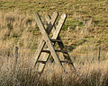
If you grep through the great_britain.osm there are upwards of 2500 stile entries–not many entries compared to how many there must be in the country. For walking however they are useful to indicate a field boundary, as well as to climb over and I have added entries in the mkgmap features.csv to display them on my Garmin GPS. If the name tag is not entered, however, it only shows up as ‘point’. If people added a name each time it would show up more usefully as ‘stile’–or gate, etc.
So my question is! Could those people that do find a stile in there way and mark it, also add a name tag?
I think that’s a renderer issue, really. When I’m out walking I usually tag stiles, but I’m not going to gratuitously add a name to them just because a particular output doesn’t recognise them otherwise - the trick is fixing the renderer, not entering unnecessary data.
Incorrectly tagging something to influence a data consumer is probably one of the few areas of OSM that has nearly unanimous consensus. The view is do not do it. Either change mkgmap to output what you want or preprocess the .osm file.
Richard, and the_winch are right. You should use a preprocessor that adds the required name tag before letting Mkgmap having a go at it. Generating a cycle map for Garmin also uses a preprocessor which works quite easy, maybe you can have a look at that to see how it can be done.