In your first step, I missed the index parameter.
This one is crucial. It reads the location from the style file parameters and puts the info in the img tiles.
In the second step another index is created, but it misses some location info that lacks in the individual tiles.
Maybe Wanmil can confirm this, because it is just a wild guess. I can partly reproduce the error when I first make an img tile without the --index (Prinsengracht,30,ABC) and then compile a new map with the --index parameter.
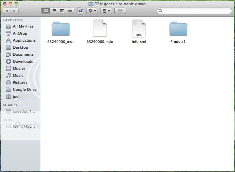
I’ve used you nifty site many times to generate custom maps to send directly to my 60CSx. Now I’m trying desperately to use Base Camp on Mac OSX (ML). First I downloaded the “osm_generic_macosx.zip” file and Mac seems to extract it, but I can’t figure out or seem to Google what to do from there? There doesn’t seem to be any install file or anything I can import to Base Camp on Mac… (I could be missing something obvious I’m very new to Mac) Thanks a lot for the great site
I have one little idea:
I often use a custom selection of tiles. It would be nice to do the tile selection by loading a tiles.txt file from a previous download to get the same selection as before.
Ough, just watch out for the obvious things… I missed that too that the index parameter was not there.
Without index parameter the bounds files are not used. And I think the address information should be completely missing (but I would have to step through the source code to know that for sure…).
The second step merges the tiles only and does not add any information to the tiles. So if index is missing on the first step the information from the bounds files will not be added on the second step.
Tried restarting and opening/closing Base Camp. Read something about red tiles, but I haven’t seen any. Are there any known issues? I have the map on my 60CSx now but I could really use it on Base Camp to plan long routes
So I dl the zip file for Mac, I double click to extract it, open Base Camp and double click a file? Edit: I tried to dl a new map but I’m stuck at the same place. I double click the zip file and Mac extracts it, but I can’t find anything to open after that.
Apparently, the HTTP request is so large that it is split into multiple packets. This can confuse some HTTP proxies and firewalls performing certain protocol checks:
.Voilá, that worked. If anyone else with a SonicWALL firewall encounters the same problem, this is the workaround:
I tried to create a containing germany, austria, switzerland and some parts of italy. While submitting the request I get the following error:
Request-URI Too Large

The requested URL's length exceeds the capacity limit for this server.
Apache/2.2.22 (Ubuntu) Server at osm2.pleiades.uni-wuppertal.de Port 80
I think this because the request is sent as as HTTP GET request, which is limited by size. Would it be possible to accept the request as a HTTP POST request, which dies not have a limitation of size. Or is this limitation to prevent to large requests?
I hope that’s it ligfietser. Although I pretty sure the --index parameter was left out for a reason but, alas, can’t find it anymore.
I’ve started a new update, let’s see what it does. Thanks!
Great, I’m glad you worked it out yourself
I think I’ll rewrite the submit to use an http post method, that would solve the server (and proxy) limitations. Maximum tilecount checks are also performed in the code and will let you know when you request too many tiles.
Edit: The request has now been rewritten as a POST request (and will now also open in a new browser window/tab).
Your welcome. It will hopefully also solve the ‘problem’ of receiving the same email multiple times for people who leave the ‘request accepted’ tab open when restarting their browser/computer.
Next development will be permalinks for easy selection of the same areas/points, e.g. the Alps, Benelux, Andes between map updates. These permalinks can then be shared on e.g. a wiki page or stored as a browser bookmark. I’m currently thinking of using the WKT format which is easily readable. This will probably be a long awaited and exciting development for many although the current mousedrag-select feature already comes a long way.
I used JaWaVa GMTK to change the FID and all the map names.
I have downloaded another OSM map from the same site and using the windows installer have tried to install but get the error message “OSM generic routable already installed…”.
Is it possible to install a second OSM map when one is already installed on the computer?
@Gavinx I suppose you could run the uninstaller because it only removes the previous uninstaller (if you renamed the FID and map names I dont think it will delete them)
@Lambertus, running GTMK I see there is a mismatch in the product code of the TYP file (it still uses PID=3 instead of 6). I have changed that in the typ file, you can grab it here. If you are using other PID’s or FID’s you can better use the txt file in your mkgmap parameters, because mkgmap automatically correct them with the internal typ compiler.