Great. Fixed a few other bugs and included some stuff from requests etc today, so I think it’s about time for the beta baby to get some prime time. ![]()
Hope all goes well…
Great. Fixed a few other bugs and included some stuff from requests etc today, so I think it’s about time for the beta baby to get some prime time. ![]()
Hope all goes well…
Thanks Eggie and Lambertus, great tool, I also read the FAQ and started the procedure as follows:
In “Extra” - “Change Map Name and ID” I did change everything which was available:
Family ID from 2000 to 905,
Name on Computer, (RussiaOSM)
Name on Device, (RussiaOSM)
Folder Name (RussiaOSM)
However, when I tried to install the bigger “Germany” Map it said again:
“OSM World Routable is already installed”
Click “OK” to remove the previous version or “Cancel” to cancel this upgrade.
BTW, I did use the CTRL G several times, and repeated the whole procedure 3 times with the same result!
Any ideas? Thanks…
P.S.: I wonder how the name “OSM orld Routable” can still remain, although everything has been changed, am I doing something wrong?
P.P.S.:The Tool is great, if only it would work:D:D:D
P.P.P.S.: GArmin GPSMAP 60CSx, GPSMAP62s, JaVaWa GMTK Ver2.4
Howdy Eggie & Lambertus and others,
Interestingly enough, now I tried one more, and it said again:
“OSM World Routable is already installed”
Click “OK” to remove the previous version or “Cancel” to cancel this upgrade.
I clicked “OK” and it started to install, and at the end, surprise surprise, both Maps were installed, the first one as “RussiaOSM” and the German Map as "OSM World Routable (01-04-2012)… Just for your records…!
When I install another OSM, I will of course change the last installed Map ID as well, and so on…
The Maps are excellent, good on OSM
Thanks again…!
P.S.: Mapsource ver. 6.16.3
P.P.S.: Meanwhile Italia is in Semifinal, that may have triggered the JaVaWaGmtk2.4 to work ![]()
Hi,
Is something wrong with the server, or is this on my end only?!?:
http://garmin.openstreetmap.nl/,
it does not show the usual World Map with the tiles to be checked, and to download,
see below the screenshot:
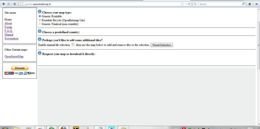
P.S.: Or is there a limit or something like that?
You’re using Firefox which I’ve also used to develop the site. Your screenshot is not normal behavior (there should indeed be a slippy map visible).
Can you force-refresh the page (ctrl-F5) or clear your browser cache and reload the page again?
Congratulations Lambertus! I have spread the news on a few forums ![]()
Thanks ligfietser, and congratulations (and thanks!) to you too! ![]()
The new site is a big improvement in usability!
One minor thing though, there is small hole when I preselect Germany, near Chemnitz.
That is the area where we will be going on holiday next month. Obviously I can manually select that tile, but I don’t need it right now so I won’t request it to keep the server happy ![]()
Thanks Lambertus, ctrl-F5 has worked… ![]()
![]()
![]()
Yes, strange that the country/tile matching algorithm is missing that tile, but the algorithm is quite complex and I don’t really feel like debugging at the moment ![]() Luckily the manual selection works fine
Luckily the manual selection works fine ![]()
Don’t worry about the server, it’s doing fine right now. Besides, the Germany map with the Chemnitz tile added is already available on the server.
Hey Lambertus, Congratulations on the new website. It works even better then the old one. Nice.
It does however does not have the latest OSM data yet. I added information 5 days ago that shows on the OSM site, but does not download yet thru openstreetmap.nl. Just curious, what can I expect for data updates.
Also saw the post for JaVaWa. That is a nice addition to my tools. Also very nice to get past the data set renaming issue.
KP
Thanks, KPost. The age of the data is shown below the map. In this case the data is from June 20th (well, actually, to be safe substract a day, so June 19th). A new update is started tomorrow when things have calmed down a bit.
BTW: the server is in throttling mode because the disk is full. About 500 (oops) 300 maps have been created (and many more downloaded) since yesterday evening. You guys are beasts ![]()
Hope those beasts also noticed the new donation button! ![]()
Haha, ligfietser ![]() No need to point to the obvious, I’ve already received two donations which allows me to buy you a beer or wine someday
No need to point to the obvious, I’ve already received two donations which allows me to buy you a beer or wine someday ![]() About 10% of the maps created so far are OpenFietsmap Lite maps.
About 10% of the maps created so far are OpenFietsmap Lite maps.
I appreciate a donation, the button is there, but don’t feel bad if you don’t or can’t. It’s a hobby afterall. I’d rather see people improve OpenStreetMap by doing some mapping or uploading tracklogs as a way of saying ‘thank you’.
LOL!
Seems like the whole world wants a new map. The harddisks are maxed-out both in performance and in space-usage, Apache is serving tiles at 100Mbit and the CPU’s are doing what they can whenever the disks have a little breathing room to provide the data… 2500 unique visitors (ok, so not the whole world, but still a lot anyway) and nearly 300 GB traffic on one day.
I haven’t seen this in a long while. ![]()
I can only predict it is going to get a whole lot busier. I have been looking at OSM many times over the years, but it was always too much of a hassle to actually use it. A good link between all that information and many Garmin users seemed to be missing. It was never really convenient to say the least. With this website, especially with the new update, that link is there and now everybody can get their maps easily. I may have missed it, but I do not see on the main OSM website a big red button that says go here to get your Garmin maps. Instead there is the “export” tab, which really is not doing much for most users I would guess.
Karst
BTW, is your donate button going to the same place as the .com website donate button??
Actually, I don’t think it’s OSM’s task to make the data available in every thinkable convenient format. OSM is about data gathering and making it available in planet form (XML or PBF format). Then third parties (like me) can do what they like with that data. I don’t even think the Mapnik slippy map on the frontpage is something that should concern OSM, but it shows what OSM is capable of, which is important to get new mappers. Anyway, this is what I think ![]()
I assume you mean the main OSM website with ‘.com website donate button’? In that case: No. The donatebutton on my website is for me personally. I do intend on share a portion of the funds there with the projects I used for the website, but also to buy my girlfriend a nice dinner to make up a little for all the time I spent on developing this site ![]()
Thanks btw! ![]()
PS. I’m new to donations and donate buttons etc. Is it customary to send a thanks email to for every donation?
If i understand everything correctly then the OpenStreetMap is just the data and the TYP-file is the layout file. For the moment we only have the TYP-file from Mapnik available, is it possible to add this one (http://www.avdweb.nl/gps/garmin/improved-garmin-map-view-with-typ-files.html) to as an option? As it shows a good difference in colors and stuff… (on http://garmin.openstreetmap.nl/)
I tried the question part: http://help.openstreetmap.org/questions/13844/can-i-make-my-own-garmin-maps-from-osm-data-and-my-own-typ-file
I don’t think that typ file is 100% compatible with the mkgmap styles. You can try to use it yourself by adjusting the Family ID (2000) Product ID (6) with a typ file editor and rename it to mapnik.typ 2000.typ and see how it looks on your map.
Yes, you can redirect the donator after payment to a specific thank you url.