I wrote a linux script based on this OSM_Combi bat script.
Don’t have the gmapsupp’s atm, will test it tomorrow, if it works i’ll post the script here.
The generated sea wasn’t visible in the mapnik.typ file (wrong draw order priorities) so I updated the typ file:
http://mijndev.openstreetmap.nl/~ligfietser/diverse/mapnik.typ(r2160).zip
In this zip file you can find two versions of this typ file, one with the default line types (mapnik-p.typ) and one with the mapnik coloured styles line types (mapnik-l.typ).
The first shows only the polygons in the mapnik colours, because the lines in the mapnik-l.typ has a fixed pixel width at all zoom levels and this looks uglier at lower zoomlevels (roads are too fat):

mapnik-l.typ

mapnik-p.typ / mapnik.typ
Hello,
I downloaded for the first time into my Garmin Nuvi the maps generated here and I have a request to make if it is at all possible.
Can the map be generated without the “woods”?
What I mean is that I live in a rural area surrounded by woods everywhere which translates into green spots on the GPS which makes the roads very hard to see.
I think if these maps are to be used for Car Gps they should just display roads, names, railways, water bodies, airports, golf courses, and perhaps buidlings and pois and such.
The map should be uncluttered imo.
Anyway thanks for offering these maps I really appreciate them.
Heres what it looks like around me… can you see the roads?
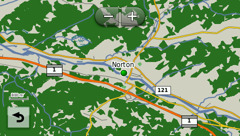
Yes, it’s easier to make the forests invisible than making the forests visible if they are not generated at all.
You only have to use and edit the mapnik.typ file I mentioned before. With the online typ file editor from http://ati.land.cz/gps/typdecomp/editor.cgi you can make the polygon type 50 (woods/forest) transparent.
Thanks for the hint lifietser… I downloaded the mapsource version and installed it but I cant find a .typ file anywhere???
Did you select “Include a typ file” before you downloaded the mapset?
If not, you can install it afterwards with Mapset Toolkit or download it again and grab an updated copy of the typ file from my site: http://mijndev.openstreetmap.nl/~ligfietser/diverse/mapnik.typ(r2160).zip

Bummer, it looks like the editor is offline… does any of your .typ files remove the green stuff?
Hi,
I’m having trouble generating a custom map- I’m trying to create a map with France plus an additional 3 tiles down to Barcelona. When I select these, enter my email address and hit “Build My Map” I get an Invalid URL error message… Any ideas what I could be doing wrong?
Cheers,
Dave
http://dc-onabike.com
Unfortunately not, you have to do it yourself. There are also offline editors, try http://pinns.co.uk/osm/ostyp.html
or Typviewer, https://sites.google.com/site/sherco40/home
It appears that the custom map server is not responding currently. I’ll request the administrator for a reboot. Thanks for reporting.
Oops, no, the server has been up and running all the time, so that’s not it. I just requested the same map as you did and did not encounter anything out of the ordinary. I received the first ‘status’ email and I’m waiting for the map to get ready…
Update: Here’s the download link for your map.
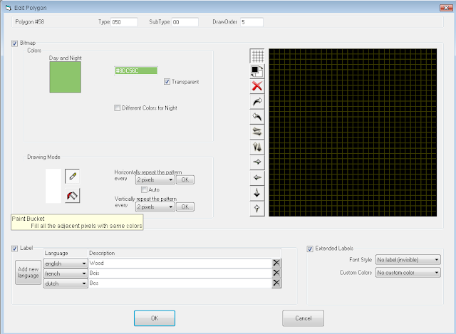
Thats too bad… Quick question, how do I make the polygon to be transparent?
I even tried to delete it from the typ file but the green always shows up.
Thanks
My favorite editor is the typviewer from https://sites.google.com/site/sherco40/home
Goto Polygons and edit type 050, in the drawing mode, switch the colour from black to white, click on the bucket and pour the white colour on the black field in the right panel.
If you delete it from the typ file, the map picks up the default Garmin colour, which is…green ![]()
Adding content for the Garmin - Experiences and advise
A couple of weeks ago I set out to add routes and interest points for a badly mapped area in Turkey with the intention to use the result on my Garmin. Unfortunately the next weekend’s update on this system did not run, so I could only test my contributions shortly before my return to Denmark.
By and large things did not work. Here are a couple of things that I learned, which I am now correcting and I want to share:
-
It is necessary to join the roads correctly together. For navigation it is not enough that it looks nice on the map. The side road must end in a node on the main road (Potlatch shows double frame when success).
-
For this purpose it is important to have enough nodes on the main road. Potlatch does not support addition of nodes in the middle of a road, only deletion/simplification, which may prove a pita (pain the the a… /back end) for the guy who travelled and logged and now wants to add the side road.
-
For the same reason do not try to translate collected Garmin tracks directly into importable roads. The Garmin will almost for sure simplify the long and winding road. Use the Garmin track only to ensure where you were, but draw the exact road by hand based upon the blue line, but according to the Bing photo.
-
The Garmin supports only some of the OSM interest point types. For example “my” area has almost solely Turkish and/or fish restaurants. Such do not appear in the searchable Garmin restaurant list, not even under “other”. Only when focusing (enough) in on the map the knife-and-fork-symbol will appear together with the name: Leave cuisine at “unset”. Similarly with attractions and all other types: Use only those that you have vverified up front to be known and searchable on the Garmin.
Apart from that (beginner’s learning) the end-to-end system is just great.
Some 90% of what you see here - roads, tracks, interest points and road names - were added by me when there during the last two weeks: http://www.openstreetmap.org/?lat=36.2487&lon=32.3522&zoom=12&layers=M
Next time I arrive it will all be debugged and working.
A big hooray to and for Lambertus ![]()
![]()
![]()
Good advice, it looks like you are doing a good job of mapping so far. Just to add a few things:
Yes, proper junctions is important for routing. You can check tools like Keepright, which can highlight these “almost junctions”, then fix any problems. http://keepright.ipax.at/
In Potlatch 2, you can add extra nodes - hold down Shift and click on the way. You can use this for adding junctions for side roads.
Yes, where possible it is a good idea to get several GPS tracks, then you can take an average from them, as well as the aerial imagery, to draw in the roads. Note the Bing imagery is not always accurate, it may be offset in places.
Also, depending on what your Garmin is, you could set it to record more detailed tracks. ie record one trackpoint per second. Then it should follow the road better.
This does depend on how the Garmin maps are produced, ie what options and style files they are using. It is usually a good idea to map as much detail as possible, using the correct tags. If it doesn’t show correctly on a particular map, you can report it to whoever is making the maps, and hopefully it can be fixed.
You can also check these pages, which have some helpful advice: http://wiki.openstreetmap.org/wiki/Good_practice
http://wiki.openstreetmap.org/wiki/Editing_Standards_and_Conventions
Thanks for sharing Anders,
A few remarks:
- With this tool you can check if the roads are connected: http://keepright.ipax.at/index.php?lang=en
- Use Shift-Click to add points somewhere in a road or join two roads together that are overlapping but not connected
- This is not because it is not supported by Garmin, but because they are just missing in the style sheets. Don’t withdraw them because OSM is much more than just a tool for this Garmin map. There are other maps that can render those items. Better drop a request here to make them visible on your Garmin or make a custom map to make them visible.
Ah Vclaw was just ahead of me with the same answers ![]()
Cool, thanks- yes that one works for me now. I was also trying to put together a single map of Western Europe, but the URL is too long- might have to just use smaller ones.
Thanks for the service, very cool.
Shift-click etc. Thanks, great. I just found out. Good to know as before I knew how to, someone apparently imported some of my first Garmin tracks, and thus those roads are pretty much too straight. Missing joints and multi lane roads with all lanes in one and the same direction which I experienced in the base material from down there was actually also in my near surroundings here in Copenhagen. In fact it also explained some strange behaviour I have formerly seen with Garmin’s own maps. Denmark is a multi-island-country and some (logically necessary) ferry routes were once obviously missing.
Yep debugging is a must, thx. for that link too.
As to the interest points: It DOES appear to me that Garmin shows only what it expects up front. Will keep experimenting to see what is best, and then align the lot.
Hi
In the points style file I tried to have the fuel icon pop up in the lower levels/resolution 18.
amenity=fuel { name ‘${operator}: ${name}’ | ‘${name}’ | ‘${operator}’ } [0x2f01 resolution 18]
However I did not succeed, Seems like for the lower levels this is not accepted to view points? I only need the fuel poi tot pop up earliers , but it is always visible together with the other poi’s.
gr Wim
Whilst you have some control on the zoom level by setting the resolution in the mkgmap style file, Mapsource and GPS units have internal rules about certain POI types that you can’t over-ride. I don’t think there is a definitive list as it seems to vary by GPS unit. To test if this is what’s going on, try using a different hexcode and see if you have better control over it.
Wim, you can try to use another poi type for amenity=fuel on the lower zoomlevels
amenity=fuel [0x… resolution 18-20 continue with_actions]
amenity=fuel { name ‘${operator}: ${name}’ | ‘${name}’ | ‘${operator}’ } [0x2f01 resolution 22]
0x… you have to find out by trial and error, a typ file is recommended to make the label invisible (it will clutter your map otherwise) and to modify the default icon.
The city pois are displayed at lower zoomlevels (0x01 -0x0b) but they also show up in the city search, maybe 0x28… will work?