The costline files only helps if the coastlines are correct. But especially in the east of canada, there are quite some coastlines wrong. Automatic imports are not always a good idea. In this situation the coastline files will not help at all.
I would only use coastline files if I have to use an extract where the coastline files are not complete. Else I haven’t seen a difference yet.
As the AR-Cordoba is a land-only tile (it does not cover part of the ocean) I think this is because a lake or riverbank polygon is not closed. But I could be wrong ofcourse.
Edit: oops, I’m late to the party.
Anyway, I hope that flooding problems in my maps will result in improved OSM coastlines…
@UliBär, I have tried some of Fabianowski’s Full planet coastlines but those made mkgmap crash…
@Lambertus,that blue is the sea polygon (0x32) in tile 63241589.img when you open it with gpsmapedit. So there must be some coastline wandering around on the Argentina Pampa’s
I think Wanmils’ floodblocker will help in this case.
That has always been the case, as Cyprus is part of the UK in the CIA files I’m using to identify which tile belongs to which country. Never took the trouble of removing Cyprus from the UK polygon file.
You better admit that you are afraid of Greekish or Turkish hatemail if you put this island in one of those countries sets? Cyprus is since 1960 not part of the UK
I wrote a linux script based on this OSM_Combi bat script.
Don’t have the gmapsupp’s atm, will test it tomorrow, if it works i’ll post the script here.
In this zip file you can find two versions of this typ file, one with the default line types (mapnik-p.typ) and one with the mapnik coloured styles line types (mapnik-l.typ).
The first shows only the polygons in the mapnik colours, because the lines in the mapnik-l.typ has a fixed pixel width at all zoom levels and this looks uglier at lower zoomlevels (roads are too fat):
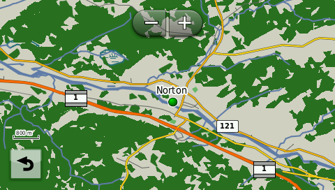
I downloaded for the first time into my Garmin Nuvi the maps generated here and I have a request to make if it is at all possible.
Can the map be generated without the “woods”?
What I mean is that I live in a rural area surrounded by woods everywhere which translates into green spots on the GPS which makes the roads very hard to see.
I think if these maps are to be used for Car Gps they should just display roads, names, railways, water bodies, airports, golf courses, and perhaps buidlings and pois and such.
The map should be uncluttered imo.
Anyway thanks for offering these maps I really appreciate them.
Heres what it looks like around me… can you see the roads?
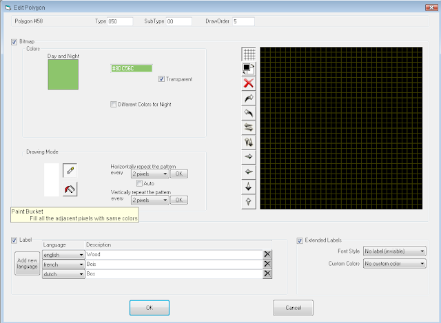
Yes, it’s easier to make the forests invisible than making the forests visible if they are not generated at all.
You only have to use and edit the mapnik.typ file I mentioned before. With the online typ file editor from http://ati.land.cz/gps/typdecomp/editor.cgi you can make the polygon type 50 (woods/forest) transparent.
Hi,
I’m having trouble generating a custom map- I’m trying to create a map with France plus an additional 3 tiles down to Barcelona. When I select these, enter my email address and hit “Build My Map” I get an Invalid URL error message… Any ideas what I could be doing wrong?
It appears that the custom map server is not responding currently. I’ll request the administrator for a reboot. Thanks for reporting.
Oops, no, the server has been up and running all the time, so that’s not it. I just requested the same map as you did and did not encounter anything out of the ordinary. I received the first ‘status’ email and I’m waiting for the map to get ready…
Goto Polygons and edit type 050, in the drawing mode, switch the colour from black to white, click on the bucket and pour the white colour on the black field in the right panel.
If you delete it from the typ file, the map picks up the default Garmin colour, which is…green