Here is the screenshot of the same. The restaurant was tagged as “cuisine=indian” but displayed as “African”. It would be even good if it is displayed as “Others” instead of “African”
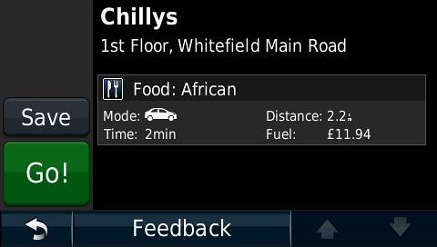
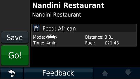
Here is the screenshot of the same. The restaurant was tagged as “cuisine=indian” but displayed as “African”. It would be even good if it is displayed as “Others” instead of “African”
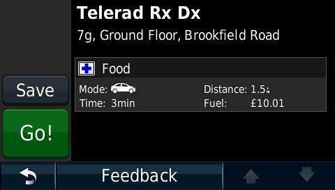
One more problem, “Hospital” is being shown as “Food” as shown in the following screenshot. The amenity is tagged as “amenity=hospital”
However, the Hospital is still listed under the POI → Hospitals. Only on the details of the Hospital, it is displayed as “Food” beside the blue “+”
These two look like bugs in your GPS. Can you try another map?
Incidentally: petrol looks hyper expensive in your area! ![]()
Routing to and from railway stations works in MS, so again, I suspect a bug in your firmware. Unless you can reproduce this in an official Garmin map don’t expect Garmin to do anything about it.
Don’t go with the currency symbol in the cost of petrol. In Indian Currency the cost is what is displayed. It is just the matter of currency symbol. Garmin is not yet providing Indian Currency symbol in their device, so I have to use the Pound symbol.
Thanks
It does not look like bugs in the GPS because the garmin map provided with the garmin navigator works fine. Even I tried with one of the commercial India map provided by mapmyindia and that works as well.
I was pulling your leg. It worked! ![]()
It still looks like a bug to me and here is why: using the free NZOpenGPS map (compiled with cgpsmapper, rather than with mkgmap, as is the case with OSM maps) I find a hospital in my GPS. I save it. It now shows under category ‘Food’. I’m using a Zumo 660, which is similar to a Nuvi, but it doesn’t have the POI display like yours does. That’s why I had to save the POI first.
I’ve tried the same thing with a hospital in Miami, which is on a Garmin NT map and the category is hospital. So the problem is confined to non-NT maps, unless the maps you have tried are also old-style, i.e. non-NT maps.
Can someone help me to display the phone number with a POI as shown in the following screenshot taken from a commercial india map(non-garmin). The navigator is Nuvi 1390T (with bluetooth).
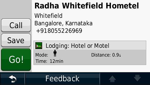
I have tagged the POI as “phone=+91 80 XXXXXXXX” but still I am not able to see the phone number on the POI detail nor does I get a “CALL” button for the OSM routable map.
Another minor problem
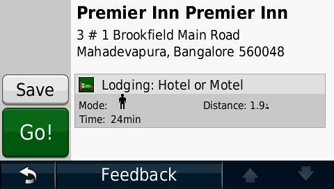
I have tagged “addr:housenumber=3-A1” but it is displayed as “3#1” as shown in the following screenshot. Any idea what is wrong.
-Nand
For those two issues I think you will have to contact the developers of mkgmap, the program used to compile OSM maps into Garmin format: http://www.mkgmap.org.uk/page/contact
I also ran into the issue that generating two sets of maps (one for home, one for a holiday) makes the Mapsource installer use the same family code(?) and thus one overwrites the other.
I don’t think the ability to specify a family for each has been implemented yet (or am I missing something?)
So I would like to combine the two sets. Is there a tutorial for this?
Thanks
It’s currently not possible to specify your own family or product id when requesting a map from the website. But I recently added a tutorial to the main page of the website which describes how you can install multiple maps concurrently. Have a look below the slippy map on the website…
In regards to the above, I was wondering, since you do provide ‘country’ maps, is there a way to maybe just add the telephone country code as a family ID or as the first few characters of the mapname?
I guess it would depend on when you split/generate the maps.
Just curious.
Well, it’s not exactly easy with the way the site has been built. The countries are an late addition in an attempt to ease the load on the system due to (repeated requests, instead of all requests being unique), but it should be possible. It’s a good idea but I don’t make promises if and when it will be implemented.
I started :-).
Just use my familiar thread class under windows first. It started with thinking about a disign with threads. I think I have some ideas.
But here is the first question. Maybe I better ask in the mkgmap group but as I’m not familiar with that group and as I suppose that you want to know that I started I ask here.
You know that in an osm file alle are summarized first. Then the and finally 's.
I will keep that.
But with threads you never know whose first done and if eigth threads do all the nodes together the output
of nodes might get in a differend order.
Would that harm mkgmap?
Ah, I assumed you were not interested because you didn’t respond ![]()
I must tell you that I’ve found a reasonably simple way around my ‘problem’: I don’t transliterate before the initial split anymore, but I transliterate the resulting files from the initial split. Since that results in a lot of tiles, I can use Translit in parallel on those files (just start multiple processes and each will transliterate one of the tiles). Sometimes the simple way is easily overlooked…
Regarding Mkgmap, I don’t know if reordering the nodes/ways/relations will impact it’s process. I guess it won’t but, admittedly, that’s a long shot.
Sorry. There was nothing to say. And I had already written that it was on my to do list.
If you had told that here it would have saved me lots of guilty feelings for taking all that processing time of you.
Sorry Greencaps ![]() Now I feel guilty, but perhaps I deserve it.
Now I feel guilty, but perhaps I deserve it.
My other question still stands though, even when the multithreading bit is not very important anymore; it would be good to have the source code of Translit available for the reasons I gave earlier.
That code is in C/C++ and I think it’s not difficult to reformat it to Java. But I did nothing with Java before. So my problem, I think, is not the conversion to Java but getting started with it.
What I need is a helping hand with choosing and installing the right Java development environment on my laptop. And then someone who takes me by the hand while openening the mkgmap code in it and telling me the place where a translit function could be integrated.
I think I then could well do this quick myself.
As I do not know anyone who could help me with this… time goes on…
First, the usual attaboys for your superb work here. You’ve made life a lot easier for many of us travelers. You make dealing with the boys and girls at Garmin almost worthwhile.
Second, I’ve successfully downloaded some tiles of Central and South America in the past. When I recently downloaded the three tile sections of New Zealand, I was unable to see any detail zoomed in closer than 200 miles. I know the street level detail is there because when I zoom down onto the (blank) map of Christchurch at 0.2 mi, I can run the mouse over the map and pick up street names, bank locations, and public toilets. But the map is starkly and resolutely blank.
I’m sure it’s not any odd settings that I am using. Just today I reloaded the maps of CA, SA, and NZ in a completely new file, installed that, and still have the same problem with NZ detail. The maps of CA and SA on the other hand are perfect, down to the finest zoom level.
Any help or guidance here would be greatly appreciated.