So, it seems that you have a modern Garmin which supports it, but many others don’t and I won’t disable the transliteration unless I’m sure that older devices handle cp1251 well too. Still, even if they do, maybe I’ll keep transliterating…
This is my first post to the forum. A million thanks to you for providing such a wonderful service. I have been using your service, the routable openstreetmap for garmin (Nuvi 1390T) for a month now and have started contributing by mapping the areas known to me during my holidays and free time. I live in Bangalore.
I do not know if this is the right forum to report bugs. I wanted to report a bug that I found on the openstreet map for garmin.
When I select “Where To” → “Point of Interest” → “Hospitals” and select a Hospital from the list of Hospitals and then click on the Name of the Hospital shown on the map, it displays “Food” (should have been “Hospital”) beside the blue “+” symbol.
Now, that is strange. I just HAD to test this out on my Zumo660 and I can search for hospitals and there is no food displayed anywhere with them. Must be specific to your Nuvi.
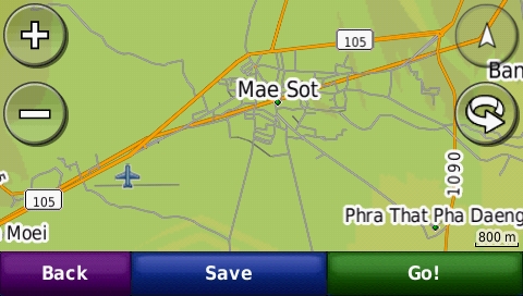
However, I have found something else disturbing: the OSM map doesn’t overlay the basemap, rather they are both displayed at the same time:
You can clearly see the basemap road going through the centre of Mae Sot and the relief shading also belongs to the basemap.
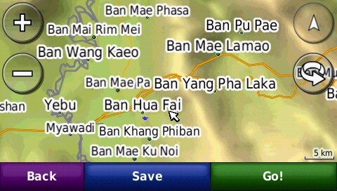
It’s still there @ 5km zoom, but zooming out any further makes most OSM data disappear, leaving just the basemap road and a few towns from the OSM map visible.
I tried disabling the basemap, but on the Zumo that doesn’t seem to be an option.
Not sure, but this might have something to do with the layer priority (e.g. the basemap has a higher priority then the OSM map). If the basemap is transparent the you’ll see what you see now. Maybe Charlie Ferrero can provide the yes/no on this?
I double checked. There is no transparency option used, so the OSM map is not (should not be!) transparent.
TYP file yes, but style no…
Altough any help with improving the default style sheet is welcome, seems the guys on the mkgmap list are not so willing to change it.
If the OSM map is being created as opaque (i.e. no --transparent option) then the base map should be hidden. I think this may be a “feature” of the Zumo. I’ve not heard of the base map showing through the OSM layer on other Garmin devices (which, in most cases, let you disable the base map anyway).
Not unless your mkgmap compile is really strange. I can’t imagine why the base map draw priority would be set high; in fact I suspect that the base map isn’t treated the same way as other maps by GPSr (at least on my GPSMap). For instance, if you try to route, the GPS will never route on the base map if another routing layer is available. I would have thought the firmware would ensure that the base map was always drawn below any other map, but that’s just a guess.
This one I installed differently: renamed the file to gmapsupp.img and copied it into the \Garmin dir on my Zumo. For Lambertus’ maps I used Mapsource to install.
Routing uses only the OSM map. I tested it, turned the OSM map off and recalc’ed. Then it used the basemap.
I have discovered another problem with garmin maps from openstreetmap. Under the “Point of Interest” → “Food”, if I select a restaurant, it displays the Category as “African” even though the restaurant is tagged as “cuisine=indian”. It works correctly for “chinese”. Again, the “Asian” category does not display any restaurant which are tagged as “cuisine=indian”. I have Garmin nuvi 1390T.
I wanted to load the screenshots of the same but do not know how to upload my images. Any help would be appreciated.
That’s interesting. “African” is not a known Garmin restaurant category. What GPS do you have?
The following assumes you are using a map created with mkgmap’s default style.
mkgmap takes OSM key-tag pairs and converts them into Garmin objects. The OSM cuisine=indian key-tag pair does not result in an Indian restaurant in the Garmin map because Garmin GPS units do not offer an Indian restaurant category. So any restaurants tagged like this are instead given the default Garmin restaurant code (0x2a13) which on my GPS at least fall under the “Other” restaurant category.
The OSM cuisine=chinese key-tag pair does have a corresponding Garmin category, hence why it works as you expected.
The only restaurants that will appear in your Asian category are those that have been tagged with cuisine=asian, as this is the only key-tag pair that mkgmap uses to generate Garmin objects in the Asian restaurant category.
If you create your own style and compile your own maps, you can assign any key-tag combination you like to any particular Garmin restaurant category. For instance, I assign the following key-tag pairs to the Garmin Asian restaurant category:
cuisine=asian | cuisine=japanese | cuisine=korean | cuisine=malaysian | cuisine=noodle | cuisine=thai | cuisine=vietnamese
Thus I get many more restaurants falling into that category for the maps that I make.
I forgot to add that I’m using the NZOpenGPS map here in NZ, compiled with cgpsmapper and I don’t have this problem. It’s only with mkgmap compiled maps.