Why aren't aqueducts in Nederlands correctly mapped?

Aqueducts are rather easily recognized as a bridge where water flows across. In some cases these objects are even named something like “…Akwadukt” or “Akwadukt…”. So there shouldn’t be any question how they are mapped.

Aqueducts are a rather important information on waterways and have to be shown on the map. Aqueducts are definitiv an important information for tourists regardless if they travel by bicycle, car or boat. And knowing that an aqueduct is ahead is informative even for drivers on highways.

Aqueducts are all over the world the same, simply transporting some water above some air and something else which clearly means a bridge. This is no different in Nederlands. Therefore aqueducts should be tagged “bridge=aqueduct” and “bridge_name=”…" on the waterway as everywhere on the world.

Water which flows goes rather seldom upwards, so aqueducts should be normally tagged “layer=0” (or no layer which implies zero) yet it’s not wrong to tag them “layer=1” or higher if necessary. Ways below should be tagged with negative layers.

Usually the water of a waterway is much wider than the waterway itself and bridges aren’t. This can be helped by a “wide=…” tag on the aqueduct. A more complex solution is to map a “man_made=bridge” according to the size of the aqueduct. With this renderer might someday render aqueducts correctly.

Now what with the under passing ways. Even in Nederlands nobody questions how waterways below an aqueduct are tagged, simply as normal waterways. So what is different with other ways, e.g. highways? Nothing is different, a way is always a way, regardless of it’s type.

Unfortunately matters aren’t that simple with highways since drivers on the highways might think of driving through a tunnel even if the know they are surpassing an wide aqueduct. In that case it’s completely acceptable to map a “tunnel=yes” to the highways.

Now what about the rule “avoid tunnels below bridges”? Well “avoid” does not mean “must not”, therefore it’s quite acceptable to not follow this rule here. Rules are never always correct and here is such a case.

When mapping we always should try to map what’s there in reality or what the user of the map sees or thinks it’s there. Only then maps might eventually give the right impression of a location.

I think I’ve now made clear how aqueducts should be mapped even in Nederlands.
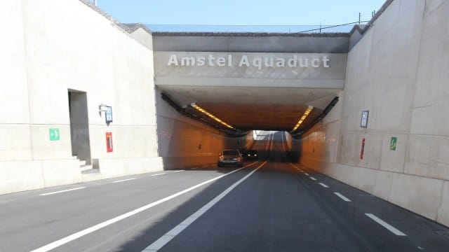
The discussion is: when should a road under an aquaduct be mapped as a tunnel?

If this is true, then why do some Nederlands mapper remove my aqueducts?

tagged man_made=aquaduct at node connected with waterway, with name=M.C. Escher Akwadukt for temp solution.
man_made is also permitted as a node.
Anyway aquaduct is in the database, but see it as a temp solution untill there is consensus.

https://www.openstreetmap.org/changeset/63937402#map=19/53.18498/5.81897&layers=N

Stupied proposition, permitted does not mean correct. There is absolute no reason to change my correct mapping. If you have a discussion tunnel=yes/no then do it without vandalizing my mapping.

The problem is that a modern aquaduct in my opinion is something completely different from mapping an aquaduct like the historic Pont du Gard or even the aquaduct over the river Loire.
If there is an solution in proper rendering with man_made=aqueduct I will be happy.

I do not agree with the man_made=aqueduct tag you suggest, I think I am largely with wyo with regards to tagging.

The Wiki pages have been quite clear and stable for this for the past few years, and you should ignore the image of the historic aqueduct used on the bridge=x page or interpret this as a general representation of modern and historic aqueducts, which is obvious from the dedicated Wiki page for bridge=aqueduct, which also shows modern aqueducts: https://wiki.openstreetmap.org/wiki/Tag:bridge%3Daqueduct

Modern aqueduct tagging:
man_made=bridge
bridge=aqueduct

IMO always on a closed way, not linear waterway. Aqueducts are mostly large scale / high zoom detail, and most useful when tagged as a closed way / polygon, instead of as an attribute of the waterway line.

Relevant Wiki pages:
https://wiki.openstreetmap.org/wiki/Key:man_made
https://wiki.openstreetmap.org/wiki/Key:bridge
https://wiki.openstreetmap.org/wiki/Tag:bridge%3Daqueduct

Historic aqueduct tagging:
historic=aqueduct

Usually tagged only as non-closed linear way. Historic aqueducts are mostly non-navigable waterways to conduct fresh water, contrary to modern day navigable structures to cross roads.

Relevant Wiki pages:
https://wiki.openstreetmap.org/wiki/Tag:historic%3Daqueduct

Hi Wyo,

I agree with the majority of what you say, but I do have my own comments about some of the arguments you give.

The meaning/defenition of a word differs between languages. Here an aquaduct can also mean a ‘short tunnel’ under some water. The defenition of what an aquaduct is is a bit looser here.

The aquaduct above is clearly a tunnel, not a water bridge…

Here in The Netherlands the land is as flat as it can be. As a boat you don’t really notice anything when going over an aquaduct. No change in views or surroundings exept a road which goes down and under you. Not much different than with regular tunnels. Just a smaller waterway.

Besides, it is not like you can really see the real structure of an aquaduct from the water anyway.

All aquaducts carry water over air, but not all structures which do so are aquaducts. Here we run into a semantics issue here over what an aquaduct actually is. While aquaducts should be tagged as bridges, a lot of people see them as small tunnels or underpasses under the existing landscape.

I fully agree with you on this.

A lot of aquaducts are structures built to carry water above the existing landscape. In a lot of cases these are man made canals for shipping or water supply. This is not the case here in The Netherlands (again, geography). All aquaducts here are basically just roads (or other ways) going under a very narrow river. The only thing which sets them apart from regular tunnels is the width of the waterway and slightly different construction (because smaller waterway).

Furthermore, waterways under aquaducts do not exist here. Natural water cannot possibly exist due to the mentioned geography, and man made water under an aquaduct (for which you have to dig a hole) is just plain stupid to have.

I also agree with you here

Most of the problems with tagging aquaducts originate from regional differences between different parts of the world. This might explain why there is such a backlash against you labeling all aquaducts bridges.

Last to answer the question in the title:

Like Hans said, it is because there is disagreement as to whether something is a water carrying bridge or short tunnel. This choice is (unfortunately) kind of subjective and it highly dependents on the individual mapper.

The current tagging might be wrong according to the definition on the wiki. But that does not mean they are not ‘correctly mapped’.

There may be a difference in interpretation here. You seem to imply that your addition of the tag bridge=aqueduct turned the mapped objects for the first time into aqueducts. The Dutch community regarded them as ‘mapped’ already before your edits, but just not in an ideal or consistent way. Two reasons for that: firstly there is no general and clear distinction between bridge and tunnel and thus no consenus when which tag to use, including for aqueducts. Secondly aqueducts can have quite different characteristics.
Just as some viaducts in The Netherlands have officially been named ‘tunnel’, some aqueducts are not real bridge-constructions but rather tunnel-like.

It would be nice if an aqueduct could be tagged somehow on the waterway but unlike you suggested in an other topic most aqueducts in The Netherlands are not really obstacles for water traffic and the canals are hardly narrowed at the passages.

Quote from the English discussion thread:

Mappers do have to take technical limitations into account. The reason that the rendering of an area man_made=bridge combined with an area like water goes wrong on OSM.org is because of that. As I have understood it would take a radical change in programming or an enormous increase of computing power. A solution is not to be expected anywhere in the near future.
Is there any other popular OSM-based map where this tagging does give a satisfying result?

I do think that an aqueduct-tag on a waterway would be desirable so they can be easily detected for water traffic. The (temporary) solution of bridge=aqueduct on a node, as suggested by Eggie, could do the job.

Why Swiss mappers don’t follow the Dutch consensus, should be the title of this threat. :stuck_out_tongue:

The definition of aqueduct shows examples that are rare in NL.

The discussion is old: 50 years ago at primary school when we were tought about aqueducts ( aquaduct in Dutch ) we wondered wether a tunnel under a waterway is called an aqueduct or not?
Now how to build a tunnel depends on the local geographic circomstances. In NL we rarely use ‘real’ tunneling as there is only soil: for short distances it is easier to just dig a trence and reconstruct whatever was above it in concrete.

Wether the resulting structure is called aqueduct or tunnel highly depends on local politics: aqueduct sounds more fancy than tunnel. But most road-users regard it as a tunnel since the road changes level and is obvious, while the waterway seems to continue without change.

What choice of tagging is used is up to the local users / habits. Just like e.g. a dirtroad: what may be called highway in Australia is called track in NL. Perhaps the Dutch are strongminded here: local planners and politicians can invent names as much as they like, we just call it a tunnel. And map accordingly. Does it matter? Not really. In fact the use of tunnel better fits the reality than aqueduct in most cases.

Sorry??? So far there doesn’t exists a single translation of “Akwadukt” mentioning anything about “tunnel”.

Then you have to ask yourself why the builder of this object have named it “Amstel Aquaduct” and not “Amstel Tunnel”. Also ask yourself what somebody thinks when one reads this name. Forgive me if can’t follow your argumentation.

I probably wouldn’t map this object as a aqueduct myself yet I also wouldn’t remove the tag if anybody else would map it.

Let’s give you an analog sample of another object. Assume you stay in front of an ordinary building like a house. Now when you look onto the map you seen a cross for a church right where the building ist. No what, are you going to remove the cross since you can’t see anything similar to a church? Probably not. Then why with aqueducts?

What’s so special about being flat? There are many more countries which are flat. There is everywhere the same meaning what an aqueduct is. When an object is named aqueduct then no question about it should even arise.

That’s never the case with any object I’ve mapped. All of them are visible albeit sometimes only when it’s too late for taking pictures. That’s another reason to see this object in advance of the map.

True not all tunnels are aqueducts. I’ll never suggest that the Dover-Calais tunnel is actually an aqueduct. Yet all objects (no exception) I’ve mapped are aqueducts. All your reasoning doesn’t change that fact.

I’m not opposing any “tunnel=yes” mapping. If anybody think it’s necessary just do it, albeit a “tunnel_name=…Akwadukt” looks rather curious.

Once again Nederlands is no different than other countries. Only the width decides if a “tunnel=yes” or not makes sense. Sorry I’m getting problems to understand your reasoning, it’s becoming more and more abstruse.

You probably don’t mean what you’ve written. What’s this https://www.openstreetmap.org/way/46739521#map=19/52.24759/6.81492&layers=N?

@wyo Please conform to the local consensus, even if you disagree. Mapping aquaduct as a waterbridge has been discussed. The standard rendering is, at the moment, not good enough. If that is improved or will be in the near future, I’m sure we will rethink this. If you want to help this along, please put your effort in improving standard rendering, not in an edit war against the national OSM community.

Why not? It follows from your reasoning. Is it the width? The construction method? The name?

Exactly. This is a semantics issue: if this particular construction was called the M.C. Eschertunnel we wouldn’t be having this discussion.

The modern Dutch (and Frisian) use of the word aqueduct just does not imply bridge.

How it was constructed should not influence the mapping since this information might be lost. Also this might lead to wrong interpretation.

Even politicians can’t decide on fancy or not. They have to rise rather much money, therefore the name isn’t chosen easily.

Do don’t really mean that! The OSM wiki is exactly made to prevent such mapping. Otherwise Nederlands driver will eventually get stuck when driving on a Austrian highway. Or Austrian driver might make large bypasses because of tracks. Therefore it’s very important that mapping is everywhere the same. So far I’ve not seen a single reason why mapping of aqueducts in Nederlands should be different.

Mapping has never ever to consider any good or bad rendering. If you consider rendering of aqueducts bad then stop mapping and starting programming yourself.

Sorry you either haven’t understood any of my reasoning or aren’t interested in a serious discussion. I don’t discuss on that level anymore.

What a statement! I’ll leave it to the Dutch (and Frisian) to comment on that.

Repeat: Please conform to the local consensus, even if you disagree.

Any world wide mapping rules overrides any local consensus unless there are important arguments otherwise. So far there are no arguments for locale mapping rules. Locale consensus has to be adjusted to the general mapping rules. So please stop mentioning locale consensus anymore.