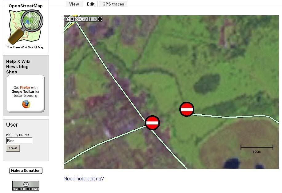
I was thinking… I recon it would be extreamly helpful to have a sign (along the same lines as the example attached), wich is stuck at the end of roads that people need to continue on further than they have got, or at junctions with more routes off than they have been down/along.
This way a person could quickly check the OSM edit page, and look at an area like bedford wich has a lot of roads, and plot there route threw the town covering these spots.
At present if i was to go to london i would need to print of an OSM map and keep compairing it to whats around me, and make quick and possibly dangerous disisions.
(these little signs, what ever they look like, would just be visible in the edit section…otherwise it would just be anoying, and stupid)
I think something like this will become ever more useful as time progresses. I’m awair there is a lot work already happening in developing the editing softwear, but this doesnt sound too difficult to impliment, if they are just a visual flag/marker/waypoint, and nothing more.
So you mean we should mark places where you can’t go any farther physcally? Like marking dead end streets? I think that’s a great idea, I would even like to take it further and have a marker for “there is lots of more here, please explore”.
I guess this could be implemented as an additional field on junction nodes, something like a “completed” flag or a numeric value indicating the number of roads (segments, actually) connected by this particular node.
Otherwise we could just create a special “sign” node (just a lat/long pair and some kind of type flag) which could be displayed on the edit mode maps.
The former has the advantage of allowing some automated way of measuring “completeness”, whereas the latter would have minimal impact on existing data (as well as being simpler to implement in the various editors, since it’s basically adding a node).
I would suggest that someone who thinks this is a good idea (and I’m not saying it isn’t) write up a small proposal detailing a few different ways to do it along with estimates of the implementation effort required and the expected benefits.
Then we just sit back and let the developers fight over it.
if you use a tag to denote nodes that have incomplete parts going from them, you can already use the JOSM selection search and the OSM-search box for looking after them.
Actually, that’s what tags are for in the first time!
I propose you just use key “unfinished” with value “yes” on every node that has some segments that aren’t tracked yet.
Ciao, Imi
PS: as a coder, I recommend not using “incomplete”, since in the coder-jargon, a way is “incomplete” (= “has incomplete segments”) if its just not fully loaded into client cache yet. E.g. in JOSM you get warnings when changing segments of an incomplete way. This has nothing to do with “the way is not yet fully tracked by people”. Just a hint to avoid confusion.
TM: It would be nice to be able to have calculations come as a result of having these signs, but at present (for simplicity of implication), I was thinking just a visual tag with no other function than to be seen. Although shorley any tag would have some computer value so could be counted up if nessesery for calculations. But…the computer would have no way of knowing if there is 2ft of road after the mark, or 100 miles. So the calculation would have no garantee other than knowing the amount of signs in ‘x’ area.
hmm Imi, you lost me. Although I think it would be equally as helpful in JOSM, i was originally refering to the online editor.
Does attaching key’‘unfinished’’ with value ‘‘yes’’ on every node not take ages, and also not offer anysort of quick visual reference.
I was/am proposing this so that a person/I could look at where im going and very quickly see where the best (in OSM terms) route is to go.
You can use the OSM website to search for the string “unfinished=yes” and then get a list of hits with links to jump directly to the online applet. To review the stuff in the applet, you have to select the A-mode and use the advanced tab.
Not nice, but working for now
There is currently no visual quick reference… :-|. But it will come. Someday. Hopefully.
“unfinished=yes” seems to do nothing in the search area of OSM.
It will be a very much appreicated feature when it comes anyway. I hope a basic tag will be quite easy to impliment shortly, as It will tern tricky route finding behind the wheel into a game of ‘spot the big ‘red?’ dot’ rather than a complicated version of ‘spot the difference’ (between a printed OSM map, and another Road map or the area around you)
(PS: As is probably quite evident, I’m no programmer. If any cgi stuff needs doing I could help in that area though)