Both HERE maps and Google maps avoid this road for car navigation although the Google street car has driven through.
.
motorcar=destination could be used for a narrow residential road that routers mistakenly use for transit/shortcut. This is tagging for the router I believe.
residential road or alley?
It does look strange on the map when a 2.5 metres wide road is rendered the same as a regular 5 metres wide road. But that is what HERE and Google also show. I would have liked this solution: highway=residential + narrow=yes. The wiki says that narrow=yes will render waterways smaller. It does nothing for highways.
I usually tag narrow residential roads this way:
highway=path for a road too narrow for a city car
highway=service + service=alley for a road between approx. 2 and 3 metres
highway=residential + lanes-tag for roads of more than 3 metres.
highway=living_street
I don’t use it. I use highway=residential instead
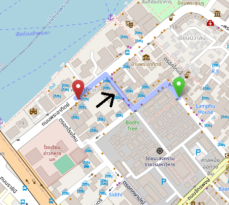
I’m curious why Soi Chana Songkhram was used as an example. Historically, it’s never been labeled as service=alley, and on Google Street View, it’s clearly marked as one-way on the north side.
Anyway, today I added extra tags: width=2.5 + lanes=1 + narrow=yes without changing the highway=service classification. I’ll report back in a few days once the routing data has been processed.
Conclusion: These results indicate to me that the argument of tagging for the router is unfounded since the default OSM router already supports additional tags like lanes, width, and even narrow: https://wiki.openstreetmap.org/wiki/Routing/Narrow_Roads
Sure, other routers may need better support, but we can all contribute to improving this together (see below).
Absolutely right, and you know what? Renderers and routers aren’t set in stone; they can be improved over time, whether through tags like narrow or lanes=1, or other means.
But software won’t improve without people submitting feedback and improvement requests.
I personally believe that as regular OSM contributors, community members, and end-users, we bear the responsibility of enhancing the OSM ecosystem, making it a better environment for everyone, including new mappers.
The easy way out is to tag for the renderer/router and repurpose tags meant for something else.
However, as you can see, this often leads to long-term contentious issues, edit wars, and a lot of wasted efforts that could have been directed towards improving the softwares instead.
On a final note, I want to thank everyone who has responded in this long thread, including our fellow mappers based in Brazil and the Philippines.
I believe there should be already ample information within this and other threads for every member of the Thailand community to make an informed decision.
So let’s proceed with the vote:
How should narrow residential roads be tagged in Thailand?
highway=residential along with any additional tags (lanes=1, width, narrow=yes, …) that will be gradually supported by routers/renderers
highway=service + service=alley for bidirectional residential roads with a width less than 3 meters
highway=service + service=alley for bidirectional residential roads with a width less than 4 meters
0voters
Important: the vote is exclusively for regular Thailand contributors and community members. Any votes from outside this group will not be counted. Thank you for your understanding!
These are only two data consumers. Both are prominent but not as dominant as they used to be. It’s quite reasonable to start there and build momentum with additional data consumers, but you might want to shop around this idea a bit more broadly just in case. Some other prominent renderers include Shortbread and OpenMapTiles.
No, this vote only concerns narrow residential roads. A “road” is considered wide enough for a standard 4-wheel vehicle (2+ meters). A “path” would be narrower.
Residential “paths” do exist in Thailand and are currently documented as highway=path based on global practices, but we can definitely revisit this here or in one of the older wiki revision thread.
Thank you to everyone who participated in the vote. It’s great to see also members from locally active companies such as TomTom and Grab adding their voice!
With over 75% of votes favoring highway=residential, we have a clear and strong consensus to proceed:
Narrow residential roads in Thailand should be tagged as highway=residential, with any additional relevant tags (like lanes=1, width=*, narrow=yes, etc.), which will increasingly be supported by routing and rendering software.
The tag service=alley should be reserved exclusively for service roads that provide access to utilities between properties —a scenario that’s relatively rare in Thailand.
When correcting roads previously tagged as service=alley or reviewing new ones, please kindly communicate with the original mapper who may not be aware of the Thailand guidelines.
@Russ_McD : I sincerely hope you’ll accept the community consensus so we can move forward and focus on other important issues.
Considering the inconsistent way lanes and widths have been applied in your use of service=alley, and the fact that you’ve added or changed over the years thousands (*) of narrow residential roads in Thailand to highway=service+service=alley, we’ll probably need to mechanically switch them all back to highway=residential with no extra tags to give them a clean slate.
(*): as of today, 5919 combined classification changes and new additions.