Let me generate one to see the latest and get back to you
Is there no more windows installer?
I send a request for a germany map and I received only these three ZIP-files:
osm_generic_tiles.zip
osm_generic_macosx.zip
osm_generic_gmapsupp.zip
http://sfs4.pleiades.uni-wuppertal.de/garmin/generic/08-09-2015/be45da3604743f7a9a458dbb2d6029f8
There is a 2GB limit for .exe
You should request a map with a smaller area.
Hi All
I’m fairly new to OSM and Mapping, but as i live in Thailand and recently bought a Garmin Zumo 390 for my bike I’ve realised that OSM maps are the best option for me to explore this great country.
I have a question -
I’ve used Lambertus excellent maps from OpenStreetMap.nl and have started adding and correcting local roads and features. I can see that the OSM official map is updated within a day, but id like to know how often Lambertus maps are updated so i can benefit from the corrections
I’ve made (some of which have a significant effect on me creating routes to get out of my town of Bangsaen.
Or is there another way to benefit from these changes?
Help and views much appreciated
Apologies if this has been discussed previously, but i did do a search with no joy…
Best Regards
Rob
Hi Rob,
Welcome on this forum. In the lower right corner of the map downloads you can see the date of the update, usually the maps are updated aevery week or a few times per month, this frequency may vary.
Thank you Ligfietser !
New style, night view, I wonder!
On Garmin’s standard maps night view gives grey maps with even darker details: Less light and contrast, more readable at night.
On ‘our’ new style night view gives the same light background as day view, but buildings shift from grey to pitch black. More contrast, less night readability.
Why?
Why? Because the night view is totally undeveloped.
Feel free to improve the typ file, I recommend to use an editor like typviewer, https://sites.google.com/site/sherco40/
OK, that’s why. Good reason.
I shall take a look and see if I can figure out how to when I sit in Turkey until end of december. Might need to ask some questions to appropriate places or persons…
Looking forward for your help andershl!
You (and others) can post your ideas, questions etc in this topic:
http://forum.openstreetmap.org/viewtopic.php?id=13257&p=12
The typ file is maintained here:
https://github.com/ligfietser/mkgmap-style-sheets/tree/master/typ/osm%20generic%20new
Cool! Style updates are automatically synchronized at each map update, which reminds me to start one now ![]()
hi guys,
why i cant choose the map type for Transparent overlay with elevation contours on http://garmin.openstreetmap.nl/.
please advice guys.
Thanks in advance.
I already posted it some time ago, but updated my own night-mode style recently.
http://osm.mueschelsoft.de/24276.typ
Feel free to use it in whatever way you like, as I feel free to continue using your nice maps.
I’m seeing an artifact where waterway=riverbank seems to be rendering under a multipolygon relation of type boundary=national_park/landuse=forest.
This isn’t a new issue; it’s been this way for years, in my memory. I’m only now getting around to finally mentioning it. And I don’t even know if it’s an issue on your side. Maybe my build process hoses things…? ![]() Something else I have to do on my side?
Something else I have to do on my side?
Location:
https://www.openstreetmap.org/#map=17/44.00832/-121.36365
Screenshots from OSM and my Garmin:
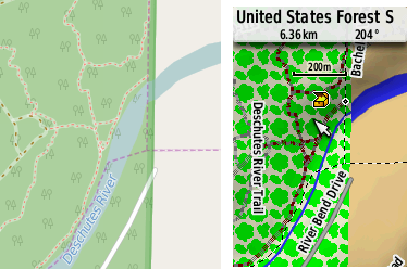
Device: Garmin GPSMap62st (FW 6.30)
Files: osm_generic_tiles.zip (North America/Oregon, Washington, California, Michigan 27-10-2015)
Tiles were merged under Linux with mkgmap --gmapsupp *.img
Thanks for the great service!
@kc voon: the map with contour lines is not available. Lambertus, better remove those future options from the website?
@mueschel thanks, I’ll have a look at your typ file
@beej71 I think it is an OSM issue, because the forest and waterbank polygons should be tagged in a multipolygon relation if one of those polygons is inside another polygon. Workaround: try the mapnik typ file or the generic new map.

@ligfietser: Works great! Looks great!
I modifed my call to mkgmap to include all the typ files from the variety of states I downloaded. I have no idea if that was the Right Thing, but it seems to have worked: mkgmap --gmapsupp *.img *.typ
Is this the right forum to make suggested additions to the TYP file? (e.g. leisure=playground, aeroway=*.)
Thanks again for the help.
Glad it works for you beej, suggestions you can place in this topic:
http://forum.openstreetmap.org/viewtopic.php?id=13257&p=12
Yesterday a big change has been made in the website regarding how country maps are spread over the available servers. Previously all country maps were provided by one server but this generates too much traffic (up to 25 TB per month!). So now country maps are, like the custom maps, spread over a selection of the available servers.
As I said, this is a big change and while it seemes to work correctly there still may be some bugs. Please report if something is not working, you see something unusual or you get an error. Thanks!