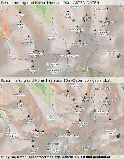
Sieht ziemlich richtig aus:
Driver: GTiff/GeoTIFF
Files: dhm_lamb_10m.tif
Size is 58808, 30323
Coordinate System is:
PROJCS["PCS Name = MGI_Austria_Lambert",
    GEOGCS["GCS Name = GCS_MGI|Ellipsoid = Bessel_1841|Primem = Greenwich|",
        DATUM["Militar_Geographische_Institute",
            SPHEROID["Bessel 1841",6377397.155,299.1528128000033,
                AUTHORITY["EPSG","7004"]],
            AUTHORITY["EPSG","6312"]],
        PRIMEM["Greenwich",0],
        UNIT["degree",0.0174532925199433]],
    PROJECTION["Lambert_Conformal_Conic_2SP"],
    PARAMETER["standard_parallel_1",46],
    PARAMETER["standard_parallel_2",49],
    PARAMETER["latitude_of_origin",47.5],
    PARAMETER["central_meridian",13.33333333333333],
    PARAMETER["false_easting",400000],
    PARAMETER["false_northing",400000],
    UNIT["metre",1,
        AUTHORITY["EPSG","9001"]]]
Origin = (106549.267203768889885,576922.512073625810444)
Pixel Size = (10.000000000000000,-10.000000000000000)
Metadata:
  AREA_OR_POINT=Area
Image Structure Metadata:
  COMPRESSION=LZW
  INTERLEAVE=BAND
Corner Coordinates:
Upper Left  (  106549.267,  576922.512) (  9d19'7.63"E, 49d 1'24.32"N)
Lower Left  (  106549.267,  273692.512) (  9d31'19.50"E, 46d17'55.02"N)
Upper Right (  694629.267,  576922.512) ( 17d21'50.31"E, 49d 1'22.34"N)
Lower Right (  694629.267,  273692.512) ( 17d 9'35.51"E, 46d17'53.15"N)
Center      (  400589.267,  425307.512) ( 13d20'28.29"E, 47d43'39.80"N)

