Please also check-out this Norwegian MTB map
It may be easier to combine its style with Israel Hiking style as I believe both are using Maperitive rules.
Please also check-out this Norwegian MTB map
It may be easier to combine its style with Israel Hiking style as I believe both are using Maperitive rules.
The styleset used on mtbmap.no is avaliable at http://mtbmap.no/maperitive/
It’s a work in progress, and mostly adjusted to work best in Norway, but I believe it will work fine anywhere in the world ![]()
There is also a JOSM styleset for easy mtb:scale tagging: http://mtbmap.no/josm/
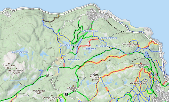
This Norwegian MTB map ( http://mtbmap.no/ ) looks great and gives the required info for MTB
I see it is limited to showing Norway only.
How can we go forward and see other regions (and specificly Israel) in this style ?
Both 4umaps http://www.4umaps.eu/online-outdoor-hike-bicycle-map.htm and sigma cycle http://www.gpsies.com/home.do;jsessionid=07C5CFDD43680E4EE5682C7E77B21FA7#15_31.83932122468829_34.922661781311035_sigmaCycle show MTB scale in Israel – the very little data that is available.
4umaps & sigma cycles are not the same quailty of “Norwegian MTB map” or “Israel Hiking Map” I would recommend to have a MTB textual data on IHM or implement an Israel MTB map similar to the Norwegian one.
Hi!
Thanks for the kind words about my Norwegian MTB map ![]()
Out of curiosity I tried to render a small part of Israel using my Maperitive styleset: http://mtbmap.no/israel.php
It would need to be tweaked a bit, removing overlapping names etc… Zoom level compared to scale is different from Norway also, because of the map projection.
Superb - exactly what we need here for MTB - Thank You
I am sure that once implemented many/most trails will be tagged with the “mtb:scale” and within few months this will be “THE MTB MAP”
As you say - still needs to be tweaked (1) names of cities & villages are shown twice, sometimes overlapped (2) almost all the names in Hebrew language appear inverted (Hebrew is written from right to left, unlike European languages…) (3) scale looks OK, 2 or 3 more levels of zoom-in would be good to have.
Question (I am not a SW or OSM specialist…): how do we go forward from here on implementing this MTB map for Israel ?
I think you should contact user zstadler. As I understand it, he (among others?) made the Israel hiking map, using the same software as me. He seems to be more skilled regarding both programming and Maperitive ![]()
The Israel hiking map is available on Github.
Think I will put my my latest styleset on Github also. But for now it’s available here: http://mtbmap.no/maperitive/
In Norway exactly this happened. At least in Trondheim (my city) and Oslo. From having close to no mtb-tagging, now most paths/tracks are tagged ![]()
I just saw a change in the implementation of the IHM,that is - the trails are shown as a layer on the map and can be shown or removed.
I think it would be good to add MTB scale as a layer as well. Practically I think the MTB scale should be marked as in the norweigien MTB map, with a transperent color, so that this coloring will not obscure any other data.
The map looks great!
I’m still thinking about the right graphical approach to combine your excellent MTB notation with the Israel Hiking map notation.
In the meantime, it would be great if you could add the following definition to handle right-to-left names in Hebrew or Arabic in “draw: text” Maperitive rules
for : @isMatch(name, "[א-ת-ݭﬠ-ﻼ]")
define
text-direction : rtl
Hi
How can we go forward with implementing a layer of MTB Scale?
I think the MTB scale should be marked as in the norweigien MTB map ( http://mtbmap.no/ ) , with transperent colors, so that this coloring will not obscure any other data. I suggest to use the same 6 colors (per the 6 scale definitions) as in the norweigen map.
I think that once imlemented riders this will be “The MTB Map” in Israel
Try to raise this propsal at the GPS/mapping forum of groopy.co.il biking site.
Many more people read it than the people here and perhaps someone would like to take on the project.
I’ve released a preliminary version of an Israeli MTB Map, following the style of the Norwegian MTB map.
The map is available at http://osm.org.il/IsraelHiking/IsraelMTBmap.html
I’d like to thank Reitstoen for the excellent map style and for allowing me to re-use it.
I’d also like to thank YGMZ for repeatedly driving me to continue.
A few things are still missing, such as a proper legend.
Please feel free to post your feedback here.
If you like it, feel free to publish it with your friends and favorite forums.
Great Job, Zeev, a wonderful asset.
A few thoughts:
Thanks for the feedback!
It made me realize that I will not be able to drive the kind of development proposed above. For example, it’s easy to see that combining the Bicycle-related information with the Hiking-related information is a complex task, and the map is at risk of becoming too complex to read. I would be more than happy to help someone else take the lead on further improving the MTB map.
All I did is take the excellent style of the Norwegian MTB map and adapt it for Right-to-Left names and remove administrative boundaries that are less relevant in Israel.
Appearance on the map is directly determined by the Norwegian MTB map style and the OSM data. If that’s not the case, please give me a specific example, and I will try to debug.
Thanks for the thoughs
Here’s my opinion:
(1) I would **not **go the “open cycle map way” because then we cannot differentiate a foot path from bicycle path. if a foot path is non ridable the tag mtb:scale = 6 (giving it a black & orange color) will show this. If a foot path is ridable, mtb:scale = 1 to 5 will show the difficulty (see foot trails tagged in Yagur area)
(2) The “samash” sometimes interferes’ especially if it is wide (like Shvil Israel) - needs some thought on how to make it better.
(3) Good idea to show bike shops
(4) Good idea to show tagged trails in bright yellow in lower zooms
(5) Good idea to show direction
(6) I would stay with the Norwegian concept, what does need thinking is the “samash”
Regarding the 1st point.
OCM marks bicycle=designated and bicycle=yes in blue and bicycle=? in brown. Standard mapnik marks bicycle=designated in blue and bicycle=yes and bicycle=? in grey. So OCM is more liberal, as should be the case for a bicycle-oriented map.
It will take time till we tag all paths with the correct MTB:scale, and until than we want to know what is rideable and what is not.
The bright yellow annotation is based on the class:bicycle:mtb tag.
Currently, there is only one trail with a class:bicycle:mtb and it is rendered correctly as transparent given its class:bicycle:mtb=-1 tag.
See the overpass-turbo map of class:bicycle:mtb trails
Just a note on the bicycle=yes tag. This is, as I understand it, a legal tag. Meaning if you are allowed to ride there or not. Same with bicycle=no.
Here in Norway many paths have been tagged with bicycle=no because some people have thought it wouldn’t be possible to ride a bike even if it’s allowed. Not thinking of how skilled many MTB riders are ![]()
Seems that the same has happened here as well
Some highways are rightfully tagged as bicycle=no, but some trails are wrongfully taged the same…
As the word is spread now, it will probably be corrected