The new server is live. At first all new custom requests will be routed to the new server and the original custom server is enabled again when it has caught up.
I’m aware of one last problem on the new server: fancy directory listing isn’t working yet.
Edit: fixed. Needed to change AllowOverrides None → all
This is difficult. As it stands now, disk space alone has little value to this service, especially the custom maps need disk space AND cpu power. The country maps could be hosted offsite but there is no need for that at this moment.
Whoops! 600 GB of custom maps in ~half a day: disk full. Map generation is idling now …
Edit: We’re updating and rebooting osm2 now and will bring it back up asap. Warning: This will kill ongoing downloads!
After updating two custom map servers will be available (but both very very busy).
Edit: I’m told that a lot of emails got stuck at another other mail server because we’re using a temporary domain. Many people will receive their ‘Map ready’ mail much later then necessary.
Now that there are two custom mapserver I needed to implement some kind of load sharing. The first version was simply based on a random selection. But it was pretty soon clear that this is not enough, so I added adaptive load balancing: if one custom map server is full then all requests go to the other.
Still tweaking the old and new servers. The old one is a bit faster now and the new one should become a bit less stop-and-go as it did the past few days.
Hi there. Thanks for the great service… However, I received a map-ready email but following the links I get to a download location which contains only the _tiles.zip, licence.txt and the typ file. In the mail it says that it should also contain:
_windows.exe = Installer for Garmin BaseCamp/MapSource (Windows).
_macosx.zip = Installer for Garmin BaseCamp/RoadTrip (Mac OSX)
_gmapsupp.zip = Combined image for direct manual placement on the GPS device (gmapsupp.img)
No idea what happened. The tiles are missing and I don’t know why but it does not appear to be symptomatic. I’ve added some extra logging so hopefully next time I know more.
I see that you requested a newer map, did that go alright?
I just clicked the tiles after selecting: http://garmin.openstreetmap.nl/
Routable Bicycle (Openfietsmap Lite)
Enable manual tile selection: checked
and selected the tiles in the map presented.
Then entered my mailadres and clicked: build my map…
The latest request has been placed in the same way.
Ok, glad to hear all is well this time. Still no idea why the tile-id’s were wrong during the previous requests. Other people didn’t seem to suffer the same problem.
On another note:
Improved the load balancing a bit more yesterday evening: the server is now chosen based on disk space AND queue length. If disk space is available then the server with the shortest queue gets the request.
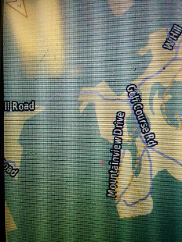
I’ve got a question / concern about rendering with the Mapnik and new-style maps…minor roads in forests are very difficult to see against the landcover on my Montana 650. E.g. http://www.openstreetmap.org/way/19729384 where it passes through natural=wood. I’ve tried setting the landcover zoom level on the device to “none”, which has worked with some other maps but doesn’t appear to have any effect. My use case is operating a dual-sport motorcycle and looking for roads and tracks through the woods, particularly when trying to find a way through an area with lots of dead ends—it’s very tough to tell, especially at a glance, if ways are mapped as going through or not.
Here’s a partial shot of the map as displayed on the Garmin, which makes the road look more obvious than it does when viewing the GPS directly:
(ignore the yellow dots, those are an overlay map I built from Vermont AOT data and indicate private roads)
Lack of contrast varies from unit to unit. In the typ file those roads are not defined, so it makes use of the internal Garmin rendering type (which makes it a Garmin problem). The only thing that you could do is adjusting the TYP file with a typ file editor and give it your own colours.
The forests are polygon type 0x15, residental roads poly lines 0x06. A good editor is TYP viewer, https://sites.google.com/site/sherco40/home
Hi, I have accidentally found there are some areas with the same .img number but different name (and different real place) in the map generated yesterday. I have found these:
63242597, named ID-Denpasar (western coast of Australia + lot of water) and ID-Banjarmasin (northern Java and southern Borneo)
63242700, named VN-Ho Chi Minh City (south-east Vietnam + Malaysia) and PH-Taguig (small area in Phillippines south-east of Manila)
63242866, named TR-Istanbul (Istanbul + Black sea north to Istanbul) and IT-Busto Arsizio (west to Milan)
As I know close to nothing about the map creation, maybe this is not the right place to report it - sorry then.