This overpass turbo map shows 18 "colour"ed ways that are not part of any hiking, MTB, or bicycle route.
Can you help determining the appropriate route type (hiking, MTB, or bicycle ), and the operator (itc - הועדה לסימון שבילים, kkl - הקרן הקיימת לישראל, or some other organization)?
In my area these 4 trails I’ve ridden and they are indeed blazed.
Around Carmey Yosef:
The red one form Tel Gezer to Ein Yarad is ITC hiking route 9251, it continues towards Kfar Bin-Nun. The black one is ITC hiking route 9255.
The blue south of Kfar Uria is ITC hiking route 9389.
The green one in Ben Shemen is part of ITC hiking route 9115.
The one north of Yavneh I’m not sure exists. I can check the next time I’m there.
Actually there is no way to know the ref number unless you consult the SAMASH maps. Is it legal for us to do that?
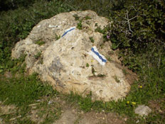
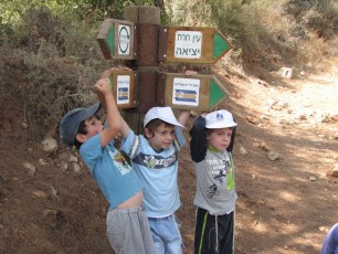
In my opinion, the marks “on the ground” are the best way to know if a trail was marked by the ITC, by KKL, or by some other authority. Information signs are also reliable for determining the “operator” of the trail.
I don’t know if it’s legal to copy the numbers from the ITC maps, but that was not my intent. Sometimes trail numbers are referenced in the Hiking Administration site of the Ministry of Education. Its terms of use include the following statements:
*המשתמש רשאי לעשות “שימוש הוגן” בחומר המוגן, לפי הכללים הקבועים בדין.
שימוש הוגן כולל ציטוט סביר מתוך החומר המוגן.
המצטט כאמור חייב לציין את המקור לציטוט, בין אם הוא המשרד ובין אם הוא גורם אחר. *
User may make “fair use” of the protected material as set out under law.
Fair use includes quoting from the protected material reasonable.
User must specify the source of the quotation, whether it is office or whether a third party.
Perhaps adding such a ref with a “source” tag is legal!?
By the way, I have temporarily excluded all trails marked as “bicycle” = “designated” from the map query. Finding the operator for them is next on my list…
Many KKL bike routes, such as Herzl, Anava, Adulam and Kanim are marked with the familiar three-stripe design of ITC rather than blazed with wooden stakes. Many are also collaborative efforts between several authorities.
My guess is that the Yavne route is bunk. Let’s delete the color and if I spot the Samash next time I’m there we’ll add it back.
Much of the mess is my doing. I’ve been adding a lot of trails lately (see below) based on the Strava data and aerial images. The colour tag is not very conspicuous as it doesn’t show in the rendering of the iD editor. If I extend an existing track and then split I may leave colored trails behind.
This was the issue with the Yugooslavia/Herzl trail in Ben Shemen.
The situation in the southern part of Anava trail is more complicated. The original route included the southern winding part from an old motorcycle single-trail. There’s been some construction there and the old KKL recording in E-yarok is no longer valid. Based on Strava, almost all riders continue straight. I’ll have to check the Samash next time I’m there. I removed it temporarily since I believe it’s no longer accessible.
